

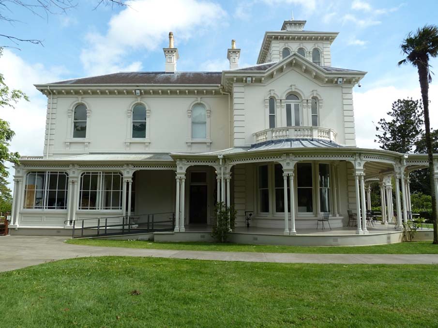
Located in Monte Cecilia Park in Hillsborough, Auckland, The Pah (Former) is a rare surviving example of a place which demonstrates the evolution of an early agricultural farm into a private designed landscape incorporating a well-preserved nineteenth-century homestead, stables and plantings. The place has outstanding aesthetic and architectural significance for its well-preserved two-storey Italianate residence with four-storey tower designed by Auckland architect Edward Mahoney, and archaeological significance associated with pre-European and colonial settlement. The place has outstanding significance for its strong historical and social associations with significant members of Auckland’s business elite including Thomas Russell and James Williamson, the earliest of a number of the owners or occupiers with strong Irish connections. Following a decade-long occupation by St John’s Collegiate School, who introduced The Whare dormitory onto the site, the Sisters of Mercy purchased The Pah in 1913. The property, bought by William Hart in 1844, was named The Pah after palisading from Whataroa Pa was uncovered during construction of the first farmhouse on the property in 1847. Specimens imported from Australia for development of the grounds are among nationally important trees surviving within Monte Cecilia Park a century and a half later. Some of these formed the basis of a designed picturesque landscape instigated by Thomas Russell in the late 1860s and augmented during the ownership of James Williamson who commissioned construction of the opulent home (1877-9) replacing the earlier homestead. Despite a century of institutional use prior to purchase by Auckland City Council in 2002 for the creation of an extensive park, the homestead has outstanding value for its original exterior form (including well-preserved servants’ wing) and little-altered interior. Ornate interior detailing includes curving window sashes in the former billiard and drawing rooms and tiled fireplaces with Italianate marble mantelpieces. Surviving fixtures include an oak dado, parquet flooring and a hall stand produced by prestigious London cabinetmakers Gillow and Co., and designed specifically for The Pah, the only residence in New Zealand known to have been furnished by the firm. The homestead is now the home of TSB Bank Wallace Arts Centre and an outstanding collection of contemporary New Zealand art.
Location
List Entry Information
Overview
Detailed List Entry
Status
Listed
List Entry Status
Historic Place Category 1
Access
Able to Visit
List Number
89
Date Entered
9th September 1983
Date of Effect
9th September 1983
City/District Council
Auckland Council
Region
Auckland Council
Extent of List Entry
Extent includes the land described as Pt Lot 2 DP 380498 (RT 464736), Secs 1-2 SO 310206 (RTs 464734, 464735), Secs 1, 3 SO 70605 (RT 55092, NZ Gazette 2002, p.444), Sec 2 SO 70605 (RT 55093, Amendment to NZ Gazette 2002 p.444, p.2158), Lot 3 DP 32733, Lot 2 DP 192435 (RTs 129959, 110987), Lot 2 DP 399421 (RT 396545), Lot 2 DP 30874 (RT NA1087/50), Lots 3-4 DP 35089 (RTs NA902/226, NA902/225), and part of the land described as Lot 1 DP 380498 (RT 322339), North Auckland Land District, and the land, archaeological sites, buildings, and structures known as The Pah (Former) thereon. It includes the Stables and the building known as The Whare and the land beneath the structures known as the Monte Cecilia Primary School but excludes the school structures themselves other than The Whare. It includes the nineteenth-century planted landscape incorporating hedging and many hundreds of trees of a large and diverse range including key species holm oak (1840s to 1880s); Moreton Bay Fig (1840s to 1870s); Norfolk Island Pine (1840s to 1880s); puriri (1860s to 1880s); English oak (1860s); Lilly Pilly and Atlantic Cedar (1880s); Bunya Pine, and Norfolk Island Hibiscus (1840s); Queensland Kauri (1840s-1870s); two Turkey oak (1850s); a hoop pine, and a camphor laurel (1850s), a relatively small number of which have been specifically identified as notable trees in the district plan and unitary plan schedule. (Refer to the extent map tabled at the Heritage List/Rārangi Kōrero Committee meeting on 8 October 2015.)
Legal description
Lot 1 DP 380498 (RT 322339), Pt Lot 2 DP 380498 (RT 464736), Secs 1-2 SO 310206 (RTs 464734, 464735), Secs 1, 3 SO 70605 (RT 55092, NZ Gazette 2002, p.444), Sec 2 SO 70605 (RT 55093, Amendment to NZ Gazette 2002 p.444, p.2158), Lot 3 DP 32733, Lot 2 DP 192435 (RTs 129959, 110987), Lot 2 DP 399421 (RT 396545), Lot 2 DP 30874 (RT NA1087/50), Lots 3-4 DP 35089 (RTs NA902/226, NA902/225), North Auckland Land District.
Location Description
The access off Hillsborough Road, known as Delargey Avenue (off which are Steins Avenue and Luck Crescent), is not legal road. The former stables building is located at the corner of Delargey Avenue and Luck Crescent. Hillsborough Road, Herd Road and Budock Roads are located in the suburb of Hillsborough. Korma Road and Mount Albert Road are located in the suburb of Royal Oak.
Cultural Significance
Social Significance or Value The place has important associations for many members of the community who have lived, worked, taught or been to school at Monte Cecilia.
Historic Significance
Historical Significance or Value The place has historical significance for its associations with early development of colonial farming in Auckland including as William Hart’s farm established in the late 1840s and as one of a number of holdings owned by Brown and Campbell, merchants and entrepreneurs who supplied beef in the colonial capital. The place is significant for demonstrating the wealth of some members of Auckland’s business elite following the third New Zealand - or Waikato - War; and for reflecting the lifestyle and affluence of Thomas Russell and James Williamson, the earliest of a number of owners or occupiers with strong Irish connections. The property also has historical significance for its long and significant association with the Catholic community in Auckland initially with the Sisters of Mercy, the first canonically consecrated order of religious women in New Zealand; and later under the Catholic Diocese, during which it had a variety of uses including as an orphanage, a novitiate house, religious educational training centre, and a facility providing emergency housing. The place has historical value for demonstrating the role of private schools in the twentieth century in the provision of education within a Christian framework: initially as St John’s Collegiate School, a boarding institution with strong Anglican connections (1902-1912); subsequently as a Catholic boarding school; and more recently as Monte Cecilia Primary, a day school for children of the local Catholic parish.
Physical Significance
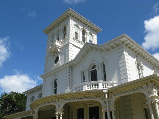
Aesthetic Significance or Value The place has aesthetic significance for its notable visual qualities. These include the impressive appearance of the two-storey plastered-brick villa with landmark tower, located on a rise within a mature parkland setting notable for its landform, fields, and extensive nineteenth-century tree plantings - including some large and unusual specimens considered regionally and nationally important. The place, enjoying panoramic views of Maungakiekie and the Manukau Harbour, incorporates the house of well-preserved form notable for its ornate external detailing including balconies, a single-storey wrap-around verandah, distinctive bay windows, entrance portico and tower. Surviving elements of the fine interior include parquet and encaustic tiled floorings, marble mantelpieces and tiled fireplaces, decorative plaster work, and timber fixtures and detailing. The associated stables building of exposed brick with slate roof and prominent gables also contributes to the high aesthetic values of the place. Archaeological Significance or Value The place has archaeological significance for incorporating the physical remnants of The Pah, an early colonial farm on the Tamaki Isthmus that evolved into a grand nineteenth-century suburban estate, representing an uncommon surviving historic landscape within metropolitan Auckland. As well as a rare wrought iron hurdle fence and three nineteenth-century standing structures (brick villa, brick stables, and timber dormitory) the site incorporates elements of the carriage drive, garden, former sites of cottages and outbuildings, rubbish pits and features associated with agricultural and residential use. The place may also contain deposits associated with the former pre-European use of the site formerly known as Whataroa. The pa site has been heavily modified and there is now no visible evidence, but some intact buried stratigraphy or features may remain. In addition to a recorded pit and midden feature, the place has potential for material and subsurface features associated with small unrecorded settlement sites, and possibly from gardening activity said to have been undertaken by Maori in the late 1830s and early 1840s. Architectural Significance or Value The place has architectural significance as a well-preserved late nineteenth-century grand residence of Italianate-influenced design, a style that found favour among some in the colony’s affluent mercantile and financial circles. The villa is one of the best surviving examples of a large house designed by Edward Mahoney, the founder of the notable Auckland architectural practice Edward Mahoney & Son well-known for ecclesiastic and commercial buildings. The well-preserved layout and interior reflects the relationship between architectural design and social status, including location of the service wing, courtyard with outbuildings to the rear of the house and stables set further away. The stables dating from circa 1879 represent a comparatively rare surviving example of such a building executed in brick. The Pah also has particular architectural significance for incorporating the well-preserved remains of an extensive, designed landscape reflecting picturesque and Italianate idioms and largely implemented over two decades commencing from 1866.
Detail Of Assessed Criteria
(a) The extent to which the place reflects important or representative aspects of New Zealand history The place reflects important aspects of New Zealand history, including acquisition of land by colonial settlers from Maori after the waiving of Crown pre-emption for a period in the 1840s; progressive European development of the landscape commencing with the establishment of agricultural holdings to supply food to early population centres including the colonial capital; the development of significant agricultural parks and estates around major city centres by prosperous members of the nineteenth-century business community; and the dispersal of many elite properties in the aftermath of the late 1880s rural depression that threatened financial institutions and brought about the collapse of companies involved in speculative borrowing to finance the development of rural land. The Pah is notable as an exceedingly well-preserved, elite landmark residence of high quality design with an associated nineteenth-century stables and a rare surviving pastoral landscape, providing an insight into the lifestyle of a small sector of the colony’s affluent business community. Its location, appearance and layout, influenced by the idealised rural settings of the British upper classes, reflects attitudes to social status among the colonial business elite in the mid to late nineteenth century and the extent to which social networks based on shared business interests and places of origin were an important part of colonial society. The place also reflects acquisition of large residential establishments by religious bodies for uses associated with private education, religious training, charitable aid and social services in twentieth century New Zealand and the role of the Catholic Church in providing such services. As St John’s Collegiate School for boys, the place reflects the role of private boarding schools in education in the early-twentieth-century and philosophies of physical fitness and discipline in personal development. The place also reflects the role of religious orders of the Catholic Church in residential care and education of girls, including homeless children. As St Mary’s Orphanage (1913-24) The Pah was one of a number of places that dealt with child welfare, but also reflected concern for the well-being of teenage women with a narrow range of employment opportunities in the early decades of twentieth-century New Zealand society. It also illustrates the role of Church bodies including St Vincent de Paul Society in meeting growing demands for social services including emergency housing in the late twentieth century. (b) The association of the place with events, persons, or ideas of importance in New Zealand history The place has special value for the strength of its association with individuals who were influential in the development of the colony’s economy. The place has strong associations with outstanding nineteenth-century New Zealand commercial figure Thomas Russell, as his suburban Auckland farm retreat. During Russell’s decade-long ownership the landscape of The Pah estate was designed on a large scale that involved construction of a grand carriage drive and extensive tree plantings, significant components of what became a private pastoral parkland. Russell, the instigator and promoter of a number of financial institutions, goldmining companies and speculative land ventures, remained an influential figure after moving to London in 1874 where he continued to exert control over the Bank of New Zealand and the New Zealand Loan and Mercantile Agency Company, while maintaining and expanding his own substantial colonial investments. The estate, encompassing late-nineteenth-century Auckland’s most palatial gentlemen’s residence, has outstanding significance for its very strong association with business leader and land speculator James Williamson who commissioned construction of the house. A founder of the Bank of New Zealand, the New Zealand Loan and Mercantile Agency Company and the New Zealand Insurance Company - institutions achieving colony-wide influence - Williamson served almost continuously on the boards of these bodies for three decades and was an instigator and the first president of Auckland’s prestigious Northern Club founded in 1869. The place also has value for its associations with early 1850s owners William Brown and John Logan Campbell, influential merchants and entrepreneurs since founding of the colonial capital in 1840 who, like James Williamson, held lucrative Commissariat contracts in the 1850s or 1860s a period of significant military presence in the colony. As Monte Cecilia, the place has significance for its long association with the Sisters of Mercy who were owner-occupiers for over six decades naming the place in honour of their founder in the colony, Mother Mary Cecilia Maher. (c) The potential of the place to provide knowledge of New Zealand history As a site with many embedded cultural layers, and former location of Whataroa Pa, the place has potential to provide knowledge about pre-colonial land use, mid-nineteenth century agriculture and the evolution of an early colonial working farm into a grand estate with park-like grounds surrounding a large house and stables, a notable survival within metropolitan Auckland. Although the pa site has been heavily modified and there are no visible remains, there may be intact buried stratigraphy and features. The presence of a Pit/Terrace site incorporating shell midden material; and acknowledged potential for remnants of small pre-European settlement sites on other slopes and ridges within the park, suggest information may be recoverable using archaeological methods to provide knowledge relating to living sites, gardening, food sources, and different eras of occupation by Maori. (d) The importance of the place to tangata whenua The place has value to Maori as the former site of Whataroa Pa constructed in the 1500s, within an area traditionally known as Koheraunui. ‘The long or expansive food store’ or ‘the long platform’ was a defended site located close to Uinui / Uhinui where root crops were extensively cultivated, near present-day Royal Oak. Paramount Tainui chief Potatau Te Wherowhero (later the first Maori king), his relative Kati and their people are said to have gardened on the site of the current Monte Cecilia Park from 1838, before selling the land in 1844 to William Hart, the first European owner. (e) The community association with, or public esteem for, the place Since Auckland City Council’s acquisition in 2002 of the surviving former Pah homestead estate to safeguard its cultural and historical values and provide a public amenity of regional significance, public esteem for the place has grown. This is particularly so, following conservation and adaptive re-use of the former homestead as the TSB Bank Wallace Arts Centre. Now housing an outstanding collection of contemporary New Zealand art, the homestead and park has become a cultural destination highly valued by the Auckland community for its heritage, art, and café. Public awareness and appreciation of the extensive landscape, with its extensive collection of heritage trees is also increasing. (f) The potential of the place for public education Located on a former pa site now a landmark park on suburban Auckland’s Tamaki Isthmus, the property has significant potential for public education for the information it reveals about pre-colonial settlement patterns; early land purchase and farming development in the 1840s; commercial and social relationships among powerful members of colonial society including their connections with financial institutions and massive agricultural landholdings; architectural and landscape design concepts from the late nineteenth century; and the lifestyle of owners of elite suburban estates and the workers employed to serve them. The place including former dormitory building (The Whare), also provides physical evidence of later institutional uses including St John’s Collegiate School, the Sisters of Mercy and Catholic Church with potential for augmentation by material held in associated archives. Apart from the former stables which is currently in separate ownership, the potential of the place for public education is extremely high due to the unaltered exterior form of the residence, the little-altered interior layout and the extent of surviving fittings, and its surviving landscape context. (g) The technical accomplishment, value, or design of the place The Pah homestead has outstanding significance for the state of preservation, extent and coherent nature of the design of the large Italianate-style house; the technical accomplishment of the workmanship involved in its construction; and the excellence of materials evident in interior plasterwork, joinery, flooring, tiles and Italian marble mantelpieces. The value of the elite residence is enhanced by the survival of an associated stables building; and the scale of the designed nineteenth-century park-like grounds including plantings revealing key view shafts to borrowed landscapes beyond the property. The setting, illustrating picturesque and Italianate influences, incorporates trees planted within a decade of colonial settlement; late 1860s elements including the carriage drive alignment, a circular scoria planting feature and oaks established as a distant focal point; along with later tree plantings and a formal late nineteenth-century garden layout with paths, steps and terraces surrounding a substantial two-storey rendered-brick house of an ornate Italianate style. The residence represents a significant building of non-commercial, secular design by Auckland architect Edward Mahoney, the founder of the noted architectural firm, Edward Mahoney & Son. The Pah homestead has particular significance as the only survivor of three similar elite residences designed by Mahoney for notable late nineteenth-century business leaders, including Sir John Logan Campbell’s Kilbryde in Auckland’s Parnell (demolished in 1924) and Waititirau designed in 1876 for Napier merchant James Watt (demolished circa 1928). The well-preserved layout of the house and pastoral setting reflects the relationship between architectural design and social status. The residence has outstanding value for its well-preserved original exterior form, and little-altered interior plan, ornate detailing, timber doors retaining their original hardware and some nineteenth-century finishes. Prestigious imported fittings surviving include curving window sashes in the former billiard room and former drawing room; tiled fireplaces with Italian marble mantelpieces; and a timber dado, parquet flooring and a hall stand with mirror, original fixtures produced by Gillow and Co. specifically for The Pah, the only residence in New Zealand known to have been furnished by the prestigious English cabinetmakers. The largely intact floorplan of the house with service wing and associated courtyard with outbuildings illustrates the lifestyle and social delineation of areas: occupied by the family and guests; where service staff lived and worked; and the manner in which activities and interactions were managed. Summary of Significance or Values The Pah (Former) is special or outstanding because it incorporates the former location of Whataroa Pa, and cultural layers encompassing pre-colonial Maori land use, mid nineteenth-century colonial agriculture, and a well-preserved late nineteenth-century landmark residence with stables in an extensive setting. The place is a rare surviving large landholding notable for its landform; and the scale of its nineteenth-century designed landscape and plantings incorporating a notable number and range of significant tree specimens of regional and national significance. The late-1870s house with associated stables, the only survivor of three similar elite Italianate-style residences designed by the noted Auckland architect Edward Mahoney for influential late nineteenth-century business leaders, has outstanding significance for its potential to provide information about nineteenth-century approaches to social status and the display of wealth. It has outstanding significance or value for the visual impact and coherent nature of its design, its well-preserved state of preservation and accomplished workmanship. The excellence of the materials used is evident in the ornate detailing which includes prestigious imported fittings including curving window sashes, and tiled fireplaces with Italian marble mantel pieces. An oak timber dado, parquet flooring and a hall stand are original fixtures produced by Gillow and Co. of London specifically for The Pah, the only residence in New Zealand known to have been furnished by the prestigious English cabinetmakers. The largely intact floorplan of the house with service wing and associated courtyard with outbuildings illustrates the lifestyle and social delineation of areas: occupied by the family and guests; where service staff lived and worked; and the manner in which activities and interactions were managed. The combined stables and coach house is a comparatively rare example of a substantial nineteenth-century facility associated with a former suburban farm estate and private residence. The potential of the house and park for public education is also extremely high given its status as a public park of regional standing.
Construction Professional
Biography
Robert Jenkinson (1834?-1913) arrived in Auckland in 1861, probably from Victoria. Working as a plasterer initially, by 1872 he was in a plastering and slating partnership styled Keane and Jenkinson. The partnership moved into building contracting, constructing John Smith’s Queen Street draper shop (1873), a new façade for Crombie’s City Club Hotel in Shortland Street (1876), the grand Auckland mansion The Pah (1877-9), and the west wing of the Auckland Mental Asylum (1878-81). Working on his own by 1882, Jenkinson was the successful tenderer for construction of the three-storey St Mungo Café, later known as Craig’s Building in Queen Street.
Name
Keane and Jenkinson
Type
Builder
Biography
No biography is currently available for this construction professional
Name
Matthews and Matthews Architects Limited
Type
Architect
Biography
No biography is currently available for this construction professional
Name
Holman, William A
Type
Architect
Biography
Edward Mahoney (1824-1895) Edward Mahoney emigrated from Cork, Ireland with his wife Margaret and three children. The Mahoneys arrived in Auckland in 1856 where Edward set up as a building and timber merchant. In 1876 he established the architectural practice that later became Edward Mahoney & Sons, which for over thirty years designed and supervised construction of many Catholic buildings as well as churches for other denominations. The Church of St John the Baptist, Parnell (1861) and St Mary's Convent Chapel (1866) are two of the earliest surviving ecclesiastical buildings designed by Edward Mahoney and reflect the gradual evolution from simple Gothic Revival structures to more ambitious and creative use of the Gothic form such as may be seen in the Church of the Holy Sepulchre, Khyber Pass (1881); and St Patrick's Cathedral, the latter completed in 1901. Edward Mahoney was a founding member of the Auckland Institute of Architects, attending the first meeting in December 1880 where he was appointed honorary treasurer. He became president of the Institute in 1883. His sons Thomas (1855?-1923) and Robert (1862-1895) joined him in practice in 1876 and the early 1880s respectively. Upon Edward's retirement in 1885, Thomas and Robert carried on the practice. After Robert's death in 1895, Thomas changed the firm's name to E. Mahoney & Son. The Mahoneys designed a wide variety of buildings including the Auckland Customhouse, hotels, commercial buildings and houses, their best-known surviving domestic buildings being the Pah, at Hillsborough (1877) and the Dilworth Terrace Houses, Parnell (1899). Their ecclesiastical buildings included St Mary's Church of the Assumption, Onehunga (1888) and St Benedict's Church, Newton (1888). The firm of Edward Mahoney & Son continued to practice for a short period after Thomas Mahoney’s death in 1923, but was eventually dissolved in 1926. Source: NZHPT Registration Report for Bank of New Zealand (Former), Devonport (Register no. 4511).
Name
Mahoney, Edward
Type
Architect
Construction Details
Description
Construction of initial timber homestead on the site
Start Year
1847
Type
Original Construction
Description
Construction of carriage drive from Pah Road
Period
1860s
Type
Physical access improvements
Description
Demolition of timber homestead, excavation of site
Start Year
1877
Type
Demolished - prior building
Description
Construction of current Pah homestead
Finish Year
1879
Start Year
1877
Type
Original Construction
Description
Construction of stables including coach house
Start Year
1879
Type
Additional building added to site
Description
Relocation of The Whare to the site (from Tamaki)
Start Year
1902
Type
Additional building added to site
Description
Addition to The Whare (dormitory, master’s room, boot / box room)
Start Year
1904
Type
Addition
Description
Conversion of Stables to laundry
Start Year
1913
Type
Modification
Description
Fire damage to laundry (former Stables), re-instatement
Start Year
1914
Type
Maintenance/repairs
Description
Conversion of drawing room to Chapel
Start Year
1926
Type
Refurbishment/renovation
Description
Alterations and additions to The Whare (fireplaces removed; new internal layout; verandah in-filled; windows modified)
Start Year
1958
Type
Addition
Description
The Whare, two classrooms converted to hall; external sheet cladding applied
Type
Modification
Description
Conversion of Stables to community house / education centre
Period
1980s
Type
Refurbishment/renovation
Description
Alterations to Stables including new concrete floor (east and west wings)
Start Year
1984
Type
Modification
Description
Alteration to Stable for caretakers flat, recreation hall, chapel
Start Year
1987
Type
Modification
Description
Restoration and strengthening of homestead for use as art gallery
Start Year
2008
Type
Restoration
Description
Slate roof of stables replaced with slate
Start Year
2009
Type
Maintenance/repairs
Description
Addition, art store abutting north external wall homestead courtyard
Start Year
2010
Type
Additional building added to site
Construction Materials
Pah Homestead: Plastered brick masonry on scoria strip foundations; timber-framed floor, ceiling and roof; slate roof Pah Stables: Exposed brick walls; slate roof The Whare: Pile foundations; timber frame; sheet cladding; corrugated metal roof
Maori History of the site The former Pah Homestead is located on the pre-European site Whataroa in Hillsborough within an area traditionally known as Koheraunui. Whataroa ‘the long or expansive food store’ or ‘the long platform’ said to be constructed in the 1500s, was a defended site close to Uinui / Uhinui where root crops were extensively cultivated near present-day Royal Oak. Whataroa Pa, of which no surface evidence remains; and a storage pit and shell midden - located on a knoll toward Mt Albert Road but within the property, are recorded archaeological sites. The area was occupied for generations by descendants of the crew of the Tainui waka. The early occupants of Koheraunui were known as Ngaoho and more locally as Ngati Poutekeka / Ngati Pou. For over four hundred years the area was occupied by Ngai Riukiuta hapu who were part of Te Waiohua. Whataroa Pa was inhabited under Kiwi Tamaki who was based at Maungakiekie / One Tree Hill. Following capture of some Tamaki Makaurau pa by Ngati Whatua in the mid 1700s, Te Taou leader Tuperiri was based at Maungakiekie. His people periodically cultivated Koheraunui as part of a wider locality. The area became deserted due to inter-regional disputes and subsequent raids by Ngapuhi in the 1820s. Paramount Tainui chief Potatau Te Wherowhero (later the first Maori King) his relative Kati and their people are said to have gardened on what is now Monte Cecilia Park from 1838 until 1844. The exact location of Te Wherowhero’s kainga near Onehunga is not known, but was described by Ngati Whatua elder, Te Warena Hengia, as being ‘near Onehunga, not far from Te Tatua’ [Three Kings]. This description suggests a Hillsborough location not far from the old pa site later occupied by The Pah homestead. Early Colonial History Ngati Whatua’s offer to transfer a large area of land to the British Crown for the colonial capital, Auckland, was formally agreed in September 1840. The Crown purchased large tracts of the Tamaki isthmus in 1840-2. An extensive area bordering the Manukau Harbour was bought by settlers in 1844 after Crown pre-emption was waived by Governor Fitzroy. In December 1844, Auckland land agent, auctioneer and hotelier William Hart, bought Koheraunui No. 1 Block from Kati and his cousin Tamati Ngapora, around the time colonial settlement commenced at nearby Onehunga. The first Pah homestead (1847-77) Notwithstanding the reduction of Hart’s land claim in December 1847 to 78 hectares (Lot 4, which he held with the adjoining 26-hectare Koheraunui No. 2, Lot 5) the agricultural holding developed in the early years of Auckland’s settlement was significantly larger than the majority of isthmus farms gradually established to supply produce to the growing urban population. Of the comparative few land claims of large size allowed in the Mt Roskill-Epsom area, only Koheraunui (Pah Farm) and One Tree Hill, were not subdivided into smaller units. Hart had a single-storey colonial regency home built in timber in 1847, the same location chosen later for the 1870s mansion that would replace it. Hart also built a barn shortly after. By 1849, the property was going by the name The Pah, palisading having been uncovered during preparations for the foundations. Tree specimens imported from Australia as part of development of the associated grounds included Moreton Bay Fig and hoop pine. The property was auctioned in October 1852 after Hart encountered financial difficulties. The purchasers were general merchants and cattle dealers William Brown and John Logan Campbell. Short-term tenants included Captain John Jermyn Symonds (1816-83) in charge of a detachment of the Royal New Zealand Fencibles settled in 1849 in Onehunga. For a period in the 1850s with James Farmer as manager of their extensive cattle interests, Brown and Campbell held the British Army Commissariat contract to supply meat to the armed forces in the capital. Farmer bought The Pah in 1855, selling in 1866 to manage Brown and Campbell’s One Tree Hill Estate nearby. The fourth Pakeha owner was County Cork-born Thomas Russell (1830-1904), who had arrived in the colony in 1840 where he went on to become a lawyer, politician and outstanding commercial figure in nineteenth-century New Zealand. Following Russell’s purchase, the landscape was designed on a large scale. In the late 1860s, a tree-lined carriage drive was constructed from Pah Road up to the homestead. David McIndoe was hired as head gardener to landscape the area surrounding the house and to plant more trees. Under a concept reflecting contemporary English and Australian examples of the picturesque, One Tree Hill and a planted circle of trees formed visual focal points for a pastoral park of seemingly natural character. Specimens included a Chilean Coquito Palm propagated from seed gifted circa 1867 by a Mr J. Burtt of Auckland to Russell and Sir George Grey, reflecting the status of horticulture and links among colonial Auckland’s elite. Under farm manager John Parfitt, the by now 125-hectare holding remained a working farm with potatoes, onions and carrots grown for export, in addition to the raising of livestock. In 1874, Russell migrated to England becoming the most influential figure in the colony’s banking affairs. There he continued to exert control over the Bank of New Zealand (BNZ) and the New Zealand Loan and Mercantile Agency Company (NZLMA) while maintaining and expanding his colonial investments which he periodically returned to visit. Construction of the current homestead (1877-9) In 1877, Russell sold the suburban farm retreat on four of the six lots to James Williamson (1814-88) a close associate as a fellow director of the New Zealand Insurance Company (NZI) and the BNZ as well as in private land investments. In July 1877, Auckland architect Edward Mahoney called tenders for the erection of a villa residence at The Pah farm. The earlier house was cleared and ground levels reduced by at least a metre. Mahoney’s design suitably reflected Williamson’s wealth and status as an eminent figure in the financial sector, a substantial landholder and the instigator and first president of Auckland’s prestigious Northern Club founded in 1869. Italianate architecture was often used for mercantile premises and residences in Auckland during the late Victorian period, being modelled on the designs of Italian Renaissance buildings associated with commercial wealth. Originally from Belfast, Williamson had arrived in Auckland in 1841 in partnership with Thomas Crummer. An astute early land purchase was the Surrey Hills farm within a mile of Queen Street. Williamson was further enriched by Commissariat contracts during the third New Zealand - or Waikato - War (1863-4) and like Russell was heavily involved in Thames goldfields investments and the acquisition of Waikato land. Briefly a member of the House of Representatives (1863-7) and the Legislative Council (1870-88), he was also a director of seven of nine interrelated public companies including the NZI, the BNZ and the NZLMA founded in 1859, 1861 and 1865 respectively, institutions that were to achieve colony-wide influence that led to Auckland’s dominance as the commercial capital of New Zealand after 1880. The grand Italianate villa of two storeys incorporating a four-storey tower was constructed of plastered brick at a time when most homes in the province were of timber, and was one of the most palatial gentlemen’s residences. The design reflected the picturesque relationship of building and landscape, a tenet of the Italianate style popular among members of the landed gentry throughout the empire following construction of Queen Victoria’s Isle of Wight retreat, Osborne House, in the 1850s. The foundation stone was laid in November 1877 and The Pah neared completion in April 1879. Classical Italianate design elements included a formal entry portico, wide verandahs and large semi-circular bay windows in two main rooms. Asymmetrical elevations and the arcaded tower with pyramid roof intensified the landmark qualities of the place. On the ground floor was a spacious hall, dining room, billiard room, study and reception rooms. Off the landing at the top of the grand staircase were seven bedrooms. In the north wing was the ground floor kitchen, food preparation area and store rooms; and staff accommodation on the floor above. The £15,000 tender price swelled by extras amounting to £3,000 or more. Williamson spent a further £11,000 on furniture and fittings from leading English cabinetmakers Gillow and Co., of London. The residence colloquially known as Williamson’s Castle was one of the most opulent in Auckland. A large underground water reservoir served the house; with a further covered reservoir near the large brick stables. The Pah’s designer, Irish-born architect Edward Mahoney (1824-95) was responsible for many important religious and commercial buildings in colonial Auckland. In 1876, his son Thomas (c.1854-1923) joined what had become Edward Mahoney and Son by mid-1878. The contractors Keane and Jenkinson, a plastering and slating partnership founded by 1872, had branched into construction work winning a number of prestigious contracts before going their separate ways in 1882. The Clerk of Works was Irish-born James Heron (1817-1908) a well-known Auckland contractor. The Pah estate (1879-1901) The stables erected around the same time at a cost of £2,000 to £3,000, originally provided for four pairs of carriage horses, several teams of working horses, hacks and a number of horse-drawn vehicles. Williamson, who retained a liveried coachman, had been a steward at the first race meeting held at the Ellerslie course in January 1857, and was a trustee and former president of what became the Auckland Racing Club. A stable of fine horses and the accoutrements were important for those seeking to recreate the idealised rural lifestyle of the British upper classes. Steps were taken to integrate the existing landscape design with the new mansion. Surrounding gardens were redeveloped in a more formal Italianate style under contract gardener John Blackmore (1845-1925) who later became head gardener with a staff of seven or eight. Formal lawns, paths, clipped trees and hedges were established along with broad steps and terraces to visually link to the contrasting pastoral landscape where further tree plantings enhanced the picturesque park-like setting. The property nevertheless remained a working farm with staff living on the property. In addition to dairyman Edward James Herd (1852-1935), market gardeners, Wong Hoy and Ching Pang, produced food for the house and the Auckland market. In late 1882, Williamson sold the Surrey Hills estate to the Auckland Agricultural Company which he had formed with Thomas Russell and others to develop farm estates on confiscated Waikato land. The Company collapsed during a deep rural depression in 1887, leaving Williamson facing bankruptcy. He died shortly after, admired as a colonist who lived, invested and died in the land where he had won prosperity, unlike absentees who enjoyed their wealth abroad. The property, mortgaged in 1889, was taken over by the BNZ in 1891. Maintaining an ongoing association between owners and occupiers with connections to Ireland, lessees in the 1890s included lawyer Peter Dignan, Auckland’s first New Zealand-born mayor. The son of prominent Auckland Catholic businessman Patrick Dignan, he hosted a lunch for the vice-regal couple Lord and Lady Glasgow at The Pah during his tenure. Noted colonial horseman Teddy O’Rorke, son of the local Member of Parliament, leased The Pah in August 1894 shortly after marrying Amy Clifford Rhodes of the prominent Canterbury settler family. O’Rorke, a master of the Pakuranga Hunt Club, steward of the Auckland Racing Club, and prominent member of the Auckland Polo Club, renovated the stables block which also incorporated the coach house and employed two grooms and a part-time stable-hand. Like many who sought to recreate British customs including a love of horses and sports, he found the cost of upkeep onerous. In April 1897, the farm was surveyed into 35 lots and progressively sold by the bank’s Assets Realisation Board. The Auckland Liberal Association unsuccessfully sought retention of the property as an agricultural college for the North Island. St John’s Collegiate School (1902-12) In February 1902, St John’s Collegiate School moved to The Pah commencing over a century’s use by educational and religious institutions. Reflecting aspects of Anglican Bishop George Selwyn’s vision for a broad range of educational facilities as part of St John’s Theological College, the private boys’ school opened in 1882 had remained at West Tamaki until the accommodation there was required exclusively for theological use. The headmaster / owner, the Reverend Percy Smallfield (1858-1952) negotiated a sales and purchase agreement for The Pah homestead on its reduced 18.6-hectare site. The ground floor housed the headmaster’s study, school office, staffroom, dining and reception rooms and a lounge for the Smallfield family who had rooms on the first floor where there were also five dormitories and two masters’ rooms. A large bathroom was constructed in the ground floor service wing, and a laundry in the former service courtyard. Gas lighting was provided. The move had involved the relocation of buildings erected by Smallfield at Tamaki. A large timber building known as The Whare (possibly the dormitory built in 1897) housed the library, the master’s room, three dormitories and a bathroom. The brick stables became a gymnasium, workshop and armoury. Athleticism was considered particularly important and most pupils were members of the school’s cadet corps. School Cadets had taken strong root in Australasia by 1902 and participation became compulsory for male students over the age of twelve under the Defence Act 1909. A regime of exercise, cold bathing and strict training was widely promoted in education circles, for buoyant health and purity. In 1904, the stables reservoir was converted to a school swimming pool. Auckland architect William Holman designed an extension to The Whare in 1904 adding a dormitory, a further house master’s room, and a boot / box room. After Smallfield failed to complete the purchase, the property was bought in 1908 by Alfreda Bayly (d.1919) the wife of a retired Taranaki grazier. The five-year lease was not renewed in 1912, after which St John’s Collegiate School closed and merged with King’s College. Most of the school buildings, except The Whare, were removed. Mount St Mary - Monte Cecilia (1913-2002) In 1913, the Order of the Sisters of Mercy and the Catholic Bishop of Auckland bought The Pah as the intended site of a central house for the Sisters of Mercy community; a new boarding school; and a replacement building for the Star of the Sea Orphanage lost to fire. The Sisters had arrived in Auckland from Ireland in 1850, the first canonically consecrated religious women to come to New Zealand. Early work by Mother Mary Cecilia Maher (1799-1878) and her seven associates included the education and care of children. By the early twentieth century, orphanages and children’s homes in New Zealand were increasingly run by churches rather than the state or charitable aid boards, who had by this time rejected institutional care as inferior to fostering. Children at the all-female institution received a general education, learned dressmaking and assisted the Sisters with the running of the small dairy farm. On attaining 15 years of age, many started work, but could remain residents until the age of 20. In 1914, the interior of a wing fitted out as a laundry in the former brick stables was damaged by fire. In 1918, the Sisters proposed operating the laundry as a commercial venture, which would provide the older girls with better paid employment than they could hope to achieve in domestic service. The 1918 influenza epidemic swelled numbers at the orphanage (also registered as St Mary’s Industrial School under the Industrial Schools Act 1882) making it Auckland’s largest facility with 145 girls in care in 1919. Following relocation of the orphanage to Howick, Mount St Mary, as the property was known, was renamed Monte Cecilia in 1925 in honour of Mother Cecilia Maher, superior general of the Auckland Sisters of Mercy for 22 years. Monte Cecilia became a temporary facility for training novices for the Order in 1926, at which time the former drawing room was converted into a chapel. The property was a boys’ boarding school from 1925 until 1951 with tree planting continuing in the 1930s. Apart from 1.6 hectares associated with school use, the property was grazed. From 1952, girl boarders were accepted and by 1964 the school was exclusively girls. Alterations made to The Whare in 1958 included removal of the fireplaces enabling a layout providing four classrooms; two cloak rooms; a common room; and teachers’ room. Windows were converted to louvre openings. An addition towards the rear of the west side largely created the current footprint. Sheet cladding increasingly replaced deteriorating board and batten exterior. Subdivision of the Monte Cecilia property began as early as 1926. In 1939, a significant portion was subdivided for St Francis Monastery Retreat Centre built in a 2.8 hectare-setting alongside other church institutions including the Marist Brothers’ training centre and Marcellin College established nearby in the 1950s. From 1965 until 1969, the homestead was a national training institution for entrants to the Sisters of Mercy Order undergoing teacher training, but became a girls’ boarding school again until 1976 when the Diocese bought the property. From 1971, Monte Cecilia Primary School was based in new classroom blocks to the west of the homestead, becoming the local school of the St John Vianney Parish in 1976. The Whare evolved to house a mix of uses including school hall, storage, cloakroom space, and a classroom. Commencing in 1976, the Monte Cecilia homestead was occupied by a diocesan religious training facility, The Chanel Institute, until allocated to the St Vincent de Paul Society for use as emergency accommodation for families in 1982. The Chapel re-opened in 1983. The then New Zealand Historic Places Trust registered the homestead and surrounds as a Category 1 historic place in 1983, making a grant of $5,000 towards a $40,000 restoration undertaken in 1985. A large palm in the back garden became important for many Pacific Island families living at Monte Cecilia House which remained an emergency housing centre until 2002. The stables were used as a community house / adult education centre in the 1980s. The floors in the northeast and southeast wings were concreted circa 1984 and toilets, kitchen, and a stairway installed. A caretaker’s flat and a recreation hall were provided in the building by 1987 as part of the Liston Memorial Retirement Village opened in 1982 the first project of the Archbishop Liston Memorial Fund. James Michael Liston (1881-1976) had become Bishop of Auckland in 1929 and over the ensuing 40 years established numerous institutions and organisations. The former reservoir was filled in 1991 and the stables roof was re-slated circa 2009. Acquisition for a Premier Park (2002- ) A 1997 subdivision proposal led Auckland City Council to acquire the homestead and 12 hectares between 2000 and 2002, bringing the Catholic Church’s 90-year association with the homestead to an end. Purchase of the school and the retirement village sites was subsequently negotiated. Monte Cecilia Park formally opened in September 2004. The homestead underwent a comprehensive restoration including structural upgrading and the fine interior was conserved and redecorated. In 2010, the building became the home of the James Wallace Arts Trust and Sir James Wallace’s outstanding collection of contemporary New Zealand art, a use necessitating construction of an art storage facility. Installation of a perimeter walk formed part of a programme of landscaping. Historic wrought iron hurdle fences were restored, along with plastered brick steps and a lower grass terrace to the east of the house.
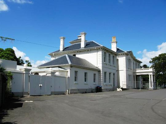
Current Description Context The Pah (Former) occupies a sandstone ridge southwest of Three Kings commercial centre, approximately seven kilometres south of the Auckland CBD. Monte Cecilia Park, a substantial public amenity of over 14 hectares, was purchased on account of special characteristics that illustrate the early history of Auckland’s settlement. A rare surviving large landholding, it is notable for its landform, its well-preserved grand 1870s homestead with associated stables building, and the scale of its nineteenth-century designed parkland landscape. Framed by Herd, Mt Albert, Hillsborough and Pah Roads, Monte Cecilia Park is recognised as an amenity of regional significance similar in stature and maturity to Albert Park, Cornwall Park, and the Auckland Domain. Less than 2.5 kilometres to the northeast is Maungakiekie and Cornwall Park, the location of The One Tree Hill Obelisk, Acacia Cottage (List entry nos. 4601 and 525, Category 1 historic places) and Stone Wall (List entry no. 526, Category 2 historic place) features strongly associated with Sir John Logan Campbell a co-owner of The Pah Farm in the 1850s. Approximately 1.5 kilometres to the southwest is the Onehunga Blockhouse (List entry no. 91, Category 1 historic place) a significant example of colonial military architecture from the era of the 1860s New Zealand Wars. Development surrounding The Pah property is mid-to-late twentieth-century housing; and Catholic institutions including the Franciscan Friary, and Marcellin College. Significant trees, formerly part of the estate, survive on adjoining properties. Fronting Pah Road beyond Monte Cecilia Park are remnants of two bluestone columns, part of the former late-1860s carriage drive entrance. The lower third of the carriage way alignment is on private properties. Layout Entrance is from Hillsborough Road. Known as Delargey Avenue, this was the original location of the drive prior to creation of the former Pah Road entrance. There is a modest frontage to Herd Road; and ‘leg in’ access on Budock, Korma and Mt Albert Roads. The landscape retains physical evidence of progressive development prior to, and following, the construction of the 1870s house. The early plantings were made with a coherent purpose, and many have been retained through the intervening land uses, up to the present. The buildings occupy a grassed terrace above two natural amphitheatres. The house with its tower and mature trees is a significant landmark, while planting and variations in landform in different parts of the park create varied qualities and views. The designed landscape, likened to an arboretum, incorporates over 1,100 trees and approximately 250 different species, a large and diverse range that includes a number of unusual and exceptionally large or old specimens considered regionally and nationally significant. Some specimens demonstrate the interest in importation of special tree types from England, Sydney and California within the early decades of the colony’s founding. Key species dominating the landscape of the grounds include holm oak (1840s to 1880s); Moreton Bay Fig (1840s to 1870s); Norfolk Island Pine (1840s to 1880s); puriri (1860s to 1880s); English oak (1860s); Lilly Pilly and Atlantic Cedar (1880s); Bunya Pine, and Norfolk Island Hibiscus (1840s); Queensland Kauri (1840s-1870s); two Turkey oak (1850s); a hoop pine, and a camphor laurel (1850s). Scheduled trees include rare specimens (Chilean wine palm); the largest examples of some species in New Zealand (Illawarra Figs, Moreton Bay Fig, hoop pine); and others that are the oldest of their type in Auckland. Large specimens of New Zealand native trees planted in the nineteenth-century include totara, puriri and pohutukawa. The pattern and type of planting enhances the basin landforms. The landscape is particularly centred round the Pah Homestead, the location and orientation of the building drawing attention to the elevation and aspect of the property. Established blocks of trees open up key view shafts to the wider borrowed landscape, Maungakiekie providing a notable focal point. Much of the historic 1860s carriageway remains well defined by the imposing presence of large Moreton Bay Figs and puriri. The carriage drive alignment, and a circular planting feature of scoria on a knoll located towards Mount Albert Road, date from Russell’s ownership. On the southwest side of the knoll, a small concrete pad with timber railings on two sides (possibly remnants of a stock-loading pen) is a rare survival from a more recent agricultural use. Two archaeological sites associated with Maori occupation on the property have been recorded by the New Zealand Archaeological Association (NZAA). Whataroa Pa (NZAA site number R11/1202), has been heavily modified by extensive earthworks associated with construction of the 1870s homestead and later creation of a sports field in the early twentieth-century. Although there are no visible remains, some intact buried stratigraphy / features may remain. Located on a knoll about 400 metres to the northeast of Whataroa Pa, is Pit/Terrace consisting of a shell midden and probable storage pit (revealed in soil profiles created by the basement walls of a house demolished in 2010). There may be remnants of unrecorded small pre-European settlement sites on other slopes and ridges. Further archaeological material other than standing structures, features under lawns and paths, and the former carriage drive alignment with curved tile drains, is likely to include former agricultural tracks, fence alignments and the former sites of earlier structures. When playing fields west of Delargey Avenue were levelled during the tenure of St John’s Collegiate School, Maori cultural material was found. The buildings associated with the extensive parkland setting are the former Pah Homestead (1877-9); the former stables (circa 1879, part of Liston Retirement Village); The Whare (relocated to the site in 1902); and modern classrooms and an office, part of Monte Cecilia Primary. The latter reflect the ongoing development of the school in the late twentieth-century, but are excluded from the List entry. However the land beneath, formerly part of the quadrangle and playing fields created by St John’s Collegiate School, are part of the nineteenth-century villa and stables setting. The Pah homestead - exterior The villa is a two-storey rendered brick structure of Italianate style on an approximately square plan with a service wing. The building graduates in height from the main house with four-storey tower; to a lower two-storey link connecting the tall hip-roofed kitchen block; and the single storey wing opening into an enclosed courtyard. A well-established tecoma hedge screens the north side and west corner of the service court and an art storage addition (2010) abutting the external north wall of the yard, as approached from the driveway. Rooms on the north side of the courtyard (the original laundry) house store rooms and building services. Within the east side of the yard is an early twentieth-century storeroom of timber construction with corrugated metal roof (the lower gallery). A mature Phoenix palm in the north lawn behind the service court is a visual accent. The virtually unaltered Pah homestead is load bearing brick on scoria strip foundations and has a timber-framed floor, ceiling and roof. The original slate roof has been replaced in places. A portico with Ionic columns and early twentieth-century red concrete pavement marks the main entrance. The building’s ashlar-patterned exterior walls have rusticated corners; and the rounded window heads have keystones and modillions. The bracketed eaves-line of the first storey incorporates low-rise gables over triple-clustered windows. The two main bedrooms on the first storey have a curved balcony. The more restrained detailing of the service wing reflects the social order and domestic arrangements associated with the suburban residences of the wealthy in nineteenth-century colonial society. Along the south, east and north elevations is a single-storey verandah supported by paired timber columns with capitals. The westernmost bays on the south elevation are glazed, possibly reflecting nineteenth-century use as a conservatory. The roof is flared and curves outward adjoining the bay windows of the drawing and billiards rooms. The living rooms open onto the verandah, and a lawn terrace where paths overlie late-1870s alignments. A pair of concrete planter urns at the northeast steps is a circa early twentieth century feature. Along the south side of the garden and east edge of the lawn, is an 1870s iron hurdle fence that protected the garden from the surrounding agricultural land. Steps down from the terrace terminate at a path on the fringe of the formal park-like agricultural landscape designed initially for Thomas Russell on the slopes facing towards One Tree Hill. The Pah homestead - interior The interior and floor plan are well-preserved with former living and service rooms located on the ground floor and bedrooms upstairs. Indoor bathrooms and lavatories, a modern innovation in the late 1870s, survive but fittings have been replaced. The Pah is the only residence in New Zealand known to have been furnished by Gillow and Co. of London, and retains part of the interior detailing and furniture fixtures made by the prestigious cabinetmaking firm established circa 1730 by Robert Gillow. The original ornate plaster centrepieces and cornices of the ground floor ceilings were reinstalled after temporary removal as part of recent strengthening work. New wall panels installed for gallery use limit damage to plastered walls. Most original door and window joinery, including original imported hardware, survives. The many Italian marble fireplaces and hearth surrounds remain in situ with the original fire registers. Minton-tiled hearths are largely a themed palette of white, black and gold. The main entrance opens into an encaustic-tiled lobby, off which is a restroom with two separate toilets. Joinery and timber panelling including plinths beside the toilet pan are original, as are lead-lighted lower window sashes giving privacy from the drive. The generously-proportioned main stair hall opens into a café (former dining room) to the north and four gallery spaces (former billiard room, ante room, drawing room and morning room) and a retail outlet (former study). The hall is notable for the parquet flooring and oak timber dado panelling imported from London cabinetmakers Gillow and Co., who were also the designers of the surviving fitted hat stand with mirror. A large mirror above the mantelpiece in the café is also believed to be by the firm. The former study with a Milners’ 212 patented safe behind a timber door has parquet flooring, and there are parquet borders around floors in the dining room and the drawing room. Flooring underlying the parquet is of pieced timber (evident in an under stair closet off the north hall). Several doors opening off the grand hall retain nineteenth-century finishes (kauri stained and grained in imitation of oak). A pelmet above the bay window in the former drawing room is a remnant of the period of use as the Sisters of Mercy Chapel. The bay windows here and in the billiard room have curving sashes and glazing, an extremely rare feature. The main staircase has a carved timber newel post. The coloured-glass arched window on the stair landing is a nineteenth-century feature, but niches were added by the Sisters of Mercy. Three of the upstairs galleries (former bedrooms) have fine marble fireplaces with tiled hearths. The main bathroom remains in the original location and retains tongue and groove linings and the original paint colour. Narrow stairs access the lower tower room which has a circular window framing Maungakiekie / One Tree Hill; and the upper tower room with panoramic views from four sides. The ground floor corridor of the service wing is divided by an east-west corridor. The original kitchen services the café. One of the west rooms has a built-in timber unit with timber wall shelving above; and a set of timber storage cupboards with glazed timber doors and cupboards below remains in the west corridor, fixtures that may date from the early twentieth-century. A small area of exposed wall (concealed until recently by an obsolete fitting in the west corridor lobby) reveals a dado painted onto the plaster. The staircase to the first floor artist-in-residence studio is located in the east corridor. Blind windows along the end portion of the north corridor once faced into the service courtyard. Stone steps part way along lead to the lower gallery (former storeroom addition with two under-floor, brick-lined, arch-vaulted water reservoirs). Remnant pipes indicate the former location of a manual pump on the east wall. Timber boards mark a former cellar hatch in the concrete floor. Former Stables Lying to the northwest of the homestead are the former stables in a grassed setting at the corner of Delargey and Steins Avenues. The squared-U-shaped plan of the one-and-a-half-storey brick building with slate roof forms a sheltered yard. The rear cross gables of the three components contribute to the building’s picturesque quality. The central cross gable bay of the former stable section has a double-door with an arched transom. Above is an open-bed pediment with circular louvre. The westernmost of the two doorways of the flanking bays has been filled in. There are two-pane sash windows on either side of both doorways. The brick-paved floor is visible in the current (2014) workshop. The back wall has small highlight windows; and a door with four-pane transom - one of three similar openings on the building’s outward-facing exterior walls. The composition of the central bay is echoed in the front gable of both wings which have an arched window rather than a door. The west wing is now a two-bedroom flat with attic. A brick chimney and original entrance indicate the former stable groom’s accommodation; and the two large in-filled archways, the coach house. Four openings with casement windows facing Steins Crescent are comparatively recent, one replacing an earlier opening. The loading door on the rear of the feed loft has been replaced, but there is a remnant of the cat’s head for lifting tackle. An opening on the ground floor has been bricked up and a new door and window created. The interior of the comparatively unaltered east wing has been lined and partitioned into a chapel, kitchen and toilets with an associated reception room and smaller chapel in part of the former stables space. The three large original arched doors opening onto the courtyard remain. Stairs to the loft have been replaced, but the interior brickwork retains a whitewash finish. The feed loft has not been redeveloped although the loading door has been bricked in. The Whare The timber-framed almost squared-U-shaped former dormitory and masters’ accommodation has a steep gabled roof of corrugated metal. The former verandah space has been incorporated into an assembly hall and has large windows and doors. Windows elsewhere have been modified by louvres. There are additional aluminium windows in locations including a circa 1959 classroom extension in the rear of the west wing. The exterior walls have been extensively re-clad in continuous sheeting. Vertical timber cladding survives on parts of the rear. The south end of the east wing (the structure relocated from Tamaki) has an area of high-quality (seasoned and dressed) beaded vertical boards. By contrast, saw marks are visible on the vertical boards of the south and east elevations of the west wing (1904 addition) where the joins are protected by wide, flattened half-round battens. Currently occupied as part of the Monte Cecilia School (2014) the building accommodates storage (east wing); a hall (central portion); and a common-room off which is a kitchen and bathroom blocked off from a classroom (west wing). Linings and ceilings are pinex and hardboard. Much of the hall floor has been replaced in narrower boards. Notwithstanding alterations, the building has a good overall form worthy of conservation and re-use. Comparisons The Pah is the sole survivor and second of three similar rendered-brick residences designed by the noted Auckland architect Edward Mahoney for influential business leaders. Waititirau designed in 1876 for Napier merchant James Watt who died soon after was demolished circa 1928; and Kilbryde erected in Parnell for John Logan Campbell in 1879 was demolished in 1924. The combined stables and coach house is a comparatively rare example of a substantial nineteenth-century facility associated with a former suburban farm estate and private residence. The stables of grand suburban Auckland houses Alberton and Highwic (List nos. 26 and 18, Category 1 historic places) have been demolished, or are a largely a timber shell, respectively. Other houses with surviving stables in Auckland include Epworth (List No. 2660, Category 2 Historic Place) and Baradene School Stables associated with the former home of Sir Edwin Mitchelson (List no. 553, Category 2 historic place). These facilities are of timber construction and substantially smaller than the Pah’s stables. The House and Stables located at 25-27 Princes Street (List no. 7732, Category 2 historic place) is a small brick facility erected in 1883 on the fringe of Auckland’s central business district. Surviving brick stables other than those associated with commercial or industrial enterprises are known to exist in the South Island at Homebush Station, (List no. 9483, Category 1 historic place); the Longbeach Station Grigg’s Stables, and Telford Woolshed and Stables (List nos. 1762 and 5199, Category 2 historic places). The Pah is one of very few elite Victorian dwellings in the Auckland region that still occupies a substantial proportion of the farm estate on which it was established. Many residences built on nineteenth-century suburban farm estates including Alberton and Highwic above, Marivare, Clifton, and Rocklands (List nos. 2642, 2623 and 7276, Category 1 historic places) and Rockwood (List no. 4502, Category 2 historic place) in Epsom, and Penrose Farm House (List no. 519, Category 2 historic place) nearby, have been alienated from their setting by urban intensification involving subdivision and development with the significant loss of their nineteenth-century curtilage and context. The property is a rare surviving example of a place which demonstrates the evolution of an early agricultural farm into a private, designed landscape incorporating a well-preserved nineteenth-century homestead and plantings.
Public NZAA Number
R11/1202
Completion Date
5th May 2015
Report Written By
Joan McKenzie
Information Sources
Hodgson, 1991
T. Hodgson, The Big House: Grand & Opulent Houses In Colonial New Zealand, Random, Auckland, 1991
Kirk, 1998
Marcienne D. Kirk, Remembering Your Mercy: Mother Mary Cecilia Maher and the first Sisters of Mercy in New Zealand 1850-1880, Auckland, 1998
Davidson, 2011
Davidson, Allan K. (ed.), Living Legacy: A History of the Anglican Diocese of Auckland, Auckland, 2011
Anon, 1952
[Anon.] Gracious is the Time: Centenary of the Sisters of Mercy, Auckland, New Zealand, 1850-1950, [Auckland, 1952]
Davis, 1911
Davis, John King, History of St John’s College, Tamaki, Auckland, 1911
Murdoc, 2013
Murdoch, G.J., Monte Cecilia our History, [Auckland, 2013]
Reidy, 2007
Reidy, Jade, Not Just Passing Through: The Making of Mt Roskill, Auckland, 2007
Report Written By
A fully referenced New Zealand Heritage List report is available on request from the Northern Regional Office of Heritage New Zealand. Please note that entry on the New Zealand Heritage List/Rarangi Korero identifies only the heritage values of the property concerned, and should not be construed as advice on the state of the property, or as a comment of its soundness or safety, including in regard to earthquake risk, safety in the event of fire, or insanitary conditions.
Current Usages
Uses: Civic Facilities
Specific Usage: Art Gallery
Uses: Civic Facilities
Specific Usage: Garden - public
Uses: Civic Facilities
Specific Usage: Tree/tree groups
Uses: Cultural Landscape
Specific Usage: Historic Landscape
Uses: Trade
Specific Usage: Cafe
Uses: Trade
Specific Usage: Shop
Former Usages
General Usage:: Accommodation
Specific Usage: House
General Usage:: Accommodation
Specific Usage: Laundry - Residential out-building
General Usage:: Accommodation
Specific Usage: Orphanage/ children’s home
General Usage:: Accommodation
Specific Usage: Servant’s quarters
General Usage:: Accommodation
Specific Usage: Stables - Residential out-building
General Usage:: Agriculture
Specific Usage: Farm
General Usage:: Education
Specific Usage: Church School
General Usage:: Education
Specific Usage: School Dormitory
General Usage:: Maori
Specific Usage: Pā
General Usage:: Religion
Specific Usage: Chapel
General Usage:: Religion
Specific Usage: Religious housing
General Usage:: Trade
Specific Usage: Laundry
Themes
Of Significance to Maori
Stay up to date with Heritage this month
