

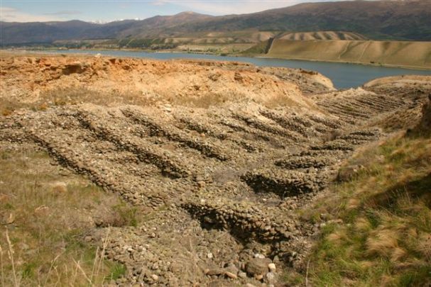
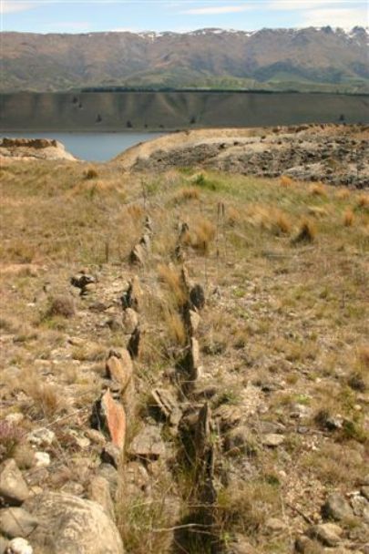
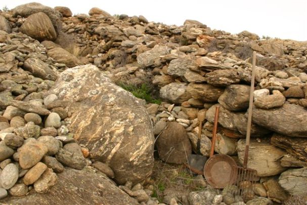
The spectacular tailings at Quartz Reef Point or Northburn provide an illustration of nineteenth century ground sluicing techniques used by gold miners in this confined area between the base of the Dunstan Range and the Clutha/Mata-au River. Geologist James Park wrote that there were three ’very rich’ alluvial leads at Quartz Reef Point. Ground sluicing involves directing the flow of ground water from a water race over the ground miners want to wash away. These tailings were part of an integrated series of features including two dams, an interconnecting head race, herringbone tailings, and the main supply race. The surviving features illustrate how ground sluicing worked. Water would have been released from holding dams and diverted through a head race over the work face, cleaning ‘gravel wash’ from the work face and creating ‘paddocks’ of gravel wash at the base of the bank. The head races are visible at the head of each herringbone finger. The wash had to be sorted to retrieve the gold while also maintaining the races and the sluice. Miners worked from the outer bank in and stacked stones at the bank edge to create a short wall and built a wall behind over which they heaped stones as the water washed the gold bearing gravels and sands down a narrow channel toward the central sluice. As the miners worked each new paddock toward the centre, a new short intermediate wall was created and the larger ‘herringbone’ wall was extended. The sluice, positioned in the central race, was the central focus of the mining operation. The sluice held gold trapping riffles, made from timber, stone, matting or tussock. There may have been a series of riffles further down the race to capture the finer gold missed by the first set. The herringbone formations at Northburn are a product of the confined space – stones that miners could not throw from the working area had to be stacked neatly so prevent collapse back on the working area or into a sluice or race. Such a system required a lot of labour – it is likely that a number of groups working at the same time created the existing system of herringbone tailings. The pattern of the tailings also reflects the gold miner’s strength – often the distance between the herringbone walls was the distance a person could throw a stone. Hundreds of thousands of cubic metres of material was removed via tail races and discharged into the Clutha/Mata-au River. Mining had largely ended the early years of the twentieth century, after which the tailings were incorporated into Northburn Station. They were declared as a historic reserve in 1977. In 2015, visitors can see the tailings as part of the Quartz Reef Point walk.
Location
List Entry Information
Overview
Detailed List Entry
Status
Listed
List Entry Status
Historic Place Category 2
Access
Able to Visit
List Number
5618
Date Entered
4th April 1985
Date of Effect
4th April 1985
City/District Council
Central Otago District
Region
Otago Region
Extent of List Entry
Extent includes the land described as Lot 1 DP 16004 (RT OT7B/455), Otago Land District, and the Northburn Tailings thereon.
Legal description
Lot 1 DP 16004 (RT OT7B/455), Otago Land District
Location Description
Off State Highway 8 between Cromwell and Crippletown. Access via Department of Conservation easement.
Stay up to date with Heritage this month
