

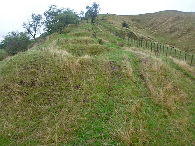
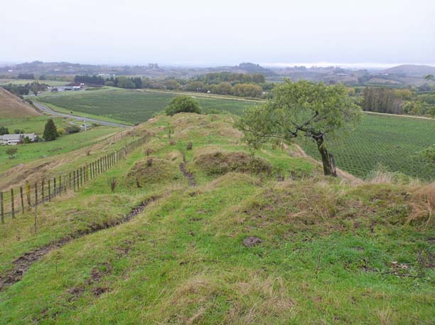
New Zealand Heritage List no. 6419 (NZAA site V21/82) is a long narrow ridgeline pā on farmland on the east side of Springfield Road, located to the west of Taradale and northeast of Waiohiki. The pā has cultural, traditional and historical significance and is one of a series of archaeological sites on the high ground above the terrace of the Tūtaekurī River. Two other pā sites lie nearby to the north. These sites are all on the western side of the hills where they have elevated views of the surrounding landscape and have utilised the natural defences of the topography. Local historian Pat Parsons has identified this pā as Parikōwhai, according to local Māori oral history. While Parikōwhai is not rare it has important archaeological contextual and information value as an element of Māori occupation and settlement of the inland Tūtaekurī River valley area. This settlement pattern is directly related to the resources and attributes of the Tūtaekurī River. The river carries silt and gravel down a narrow valley through low hill country. In its natural state swamps on the river terrace would have absorbed floodwaters and served to provide eels and other resources to sustain the nearby settlements. The pits on the pa indicate that iwi were also gardening the fertile soil of the area and storing their produce within the protective perimeter of the pā defences. This suggests they were built during a time of conflict, or in preparation for conflict. While the date of initial construction for the pā has not yet been determined it may have been constructed during a period of widespread pā building and occupation that was undertaken in the vicinity of Te Whanganui-a-Orotu and the Tūtaekurī area from 1550 to 1700, around the time that Ngāti Kahungunu iwi moved into the Hawkes’s Bay. Archaeological evidence and Māori oral history points to the initial settlement of Hawke’s Bay around 1250–1300 AD. Different hapū gradually settled the area from Māhia to Pōrangahau in a variety of diverse landscapes. About 1550 to 1625, Taraia, great grandson of Kahungunu, and his followers established themselves at Ōtātara, to the south of pā V21/82, to secure access to and control over Te Whanganui-a-Orotu and the Tūtaekurī River. V21/82 pā is on a narrow ridge with steep scarps to the river on the west and east to a gully. There are eight raised rim pits and a central platform defended by three transverse lines of ditches, banks and scarps. There are possible in-filled pits located on the flat area to the south at the base of the ridgeline. In 2014 it was noted that there are subtle changes in the ground surface up the ridge leading to the high point, which suggest that the pā may once have extended all the way up to that position and was scaled down at a later date. The features of the pā are generally in fair condition and well defined, however the site has been affected by farming activities and there has been some damage to the banks and pit rims caused by stock and farm vehicles which have cut deep ruts along the entire length of the site.
Location
List Entry Information
Overview
Detailed List Entry
Status
Listed
List Entry Status
Historic Place Category 2
Access
Private/No Public Access
List Number
6419
Date Entered
7th July 1985
Date of Effect
7th July 1985
City/District Council
Hastings District
Region
Hawke's Bay Region
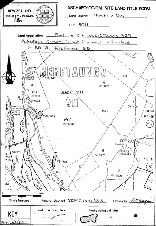
Extent of List Entry
Extent includes the land described as Area Y on Lot 2 DP 430264 (RT 517758), Hawke’s Bay Land District, and the archaeological site known as Pa (V21/82) thereon.
Legal description
Area Y on Lot 2 DP 430264 (RT 517758), Hawke’s Bay Land District
Stay up to date with Heritage this month
