

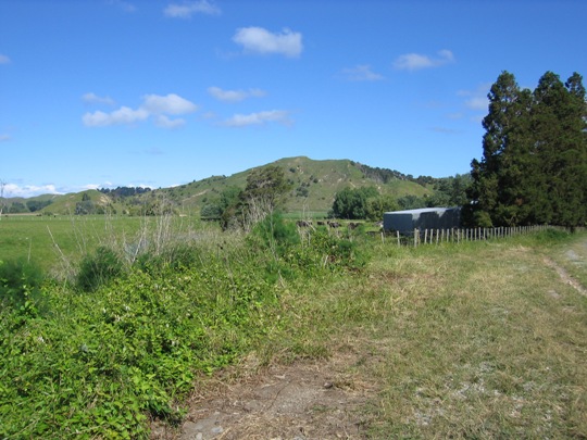
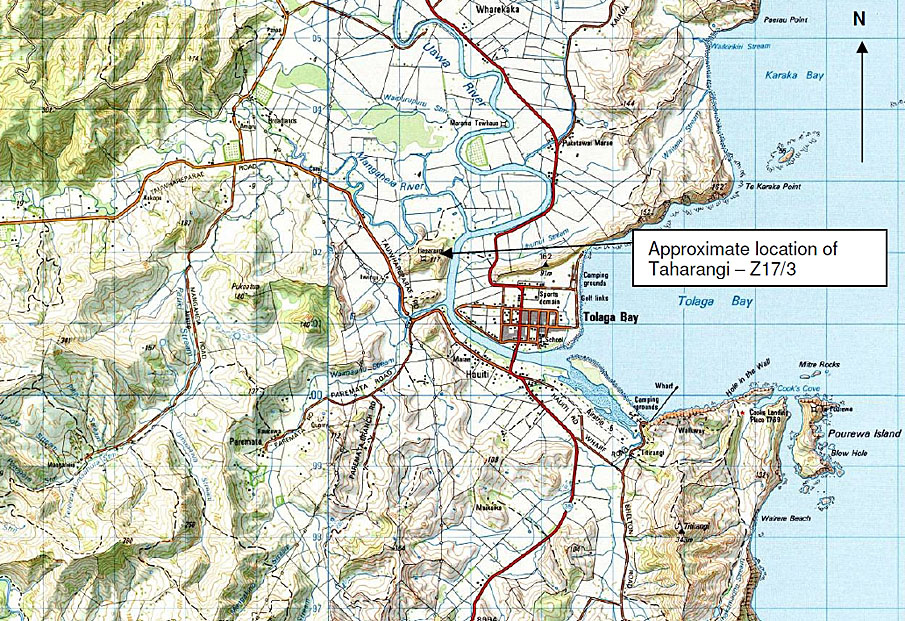
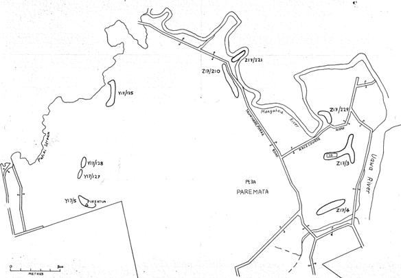
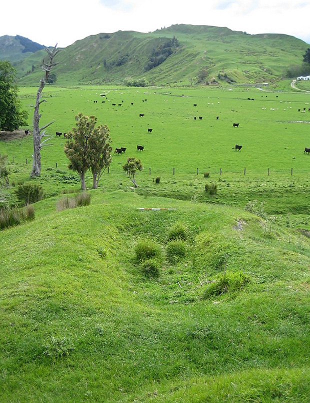
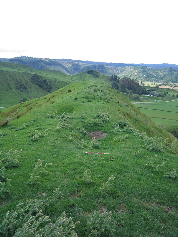
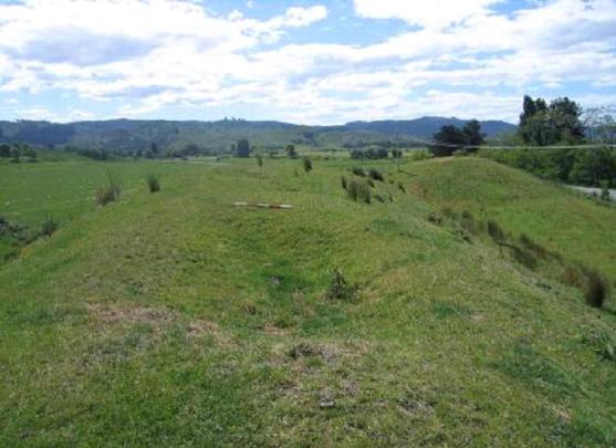
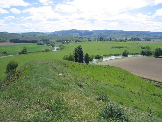
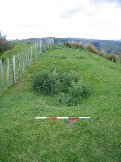
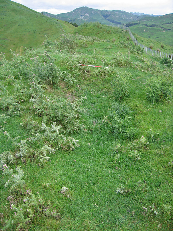
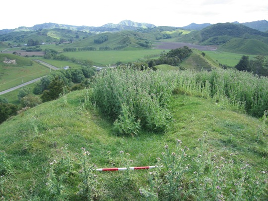
Taharangi was the pa of Te Aitanga a Hauiti chief Rangiuia and his son Tuterangiwhaitiri, and was the final site of Te Rawheoro, the famous whare wananga (school of higher learning). It is located on Taharangi hill between Tauwhareparae Road and the Uawa River, on Iwinui Station, Tolaga Bay. Taharangi is one of the numerous pa that have been recorded in the Tolaga Bay area, particularly in the Mangaheia Valley to the northwest of the township. They are mostly located on the prominent hills and ridgelines, which afforded excellent natural defences and provided commanding views of the surrounding landscape. Together with the many other archaeological sites recorded such as pit and terrace complexes, midden, gardens and urupa, they reflect the intensive occupation of this landscape by Maori from the time of initial Polynesian settlement approximately 700 years ago. A large population was able to be sustained by access to abundant food resources from the sea, rivers, inland forests and fertile soils, which were well-suited to kumara gardening. It has been estimated that the early Maori population of Tolaga Bay totalled approximately 1200; and the main iwi was Te Aitanga a Hauiti. Taharangi was the pa of Te Aitanga a Hauiti chief Nopera Rangiuia and his son Tuterangiwhaitiri, and dates from the late 18th to mid 19th century. It is depicted in a painting by trader Joseph Polack, who visited Tolaga Bay in 1835. A pa extended along the east-west running ridge top of Taharangi, and a fortified lookout was also located on the north-west running ridgeline of Taharangi, parallel to the Uawa River. This lookout served the village (Z17/24) which was located below on the south-eastern flank of Taharangi hill, on the edge of the Uawa River. All three sites were part of Taharangi. Rangiuia was the last high priest of Te Rawheoro, the whare wananga (school of higher learning) that had been established many generations before by the Te Aitanga a Hauiti ancestor Hingaroa, and was famous throughout Aotearoa. Ranguia had hoped that the teachings of Te Rawheoro would continue through his son Tuterangiwhaitiri, but his son was tragically killed at a young age, in what is believed to have been an act of witchcraft. When Rangiuia passed on in the mid 19th century, so too did the teachings of Te Rawheoro. Rangiuia was buried on Taharangi, and the name Te Rawheoro was subsequently gifted to one of the marae at Tolaga Bay. All male descendants of Rangiuia were also buried on Taharangi, and Arapeta Rangiuia was the last descendant to be buried, around 1940 or so. The area of land containing urupa (known as Te Poki) was created by a Maori Land Court Partition Order in 1924, and was formally set aside under the Maori Affairs Act 1953 as a Maori reservation for the purposes of a burial ground for Te Aitanga a Hauiti in 1974. In 1999, Taharangi and the nearby pa of Haparangi were registered as a wahi tapu area by the New Zealand Historic Places Trust, following receipt of a nomination from Te Whanau a Rangiuia, endorsed by Te Aitanga a Hauiti. Taharangi (Z17/3) is located on Taharangi hill, overlooking the Uawa River. It is currently in regenerating scrub and is accessed via Racecourse Road, which runs to the east off Tauwhareparae Road, approximately 850 metres northwest of the bridge over the Patiki Stream. Te Poki urupa is contained within the fenced off area on the top of the hill. A review of the original 1971 New Zealand Archaeological Association Site Record Forms for the two pa on Taharangi hill revealed that the hill top pa near the urupa was originally recorded as N89/5, now known as Z17/5. This conclusion is based on the site descriptions and location information provided for each site - no sketch plans/ site maps were submitted with the site record forms. N89/5 was originally described as 'a terraced cone-shaped hill rising behind N89/3'. A ridge ran from N89/5, which had 'several smaller terraces' southeast down to a lower pa (N89/3) with its two main terraces. This lower pa was located on the west bank of the Uawa River, opposite the Iwinui Stream, and was clearly visible from the main road running through Tolaga Bay to the east. This lower pa is likely to be the fortified lookout used by the inhabitants of the nearby village site, Z17/24, as referenced above. When archaeologist Kevin Jones visited Taharangi hill in 1982 during his archaeological survey work in the Whangara, Tolaga Bay and Uawa Catchment areas, he re-recorded the pa on the top of Taharangi hill as N89/3, instead of N89/5, which does not appear to have been visited. Jones described the site as a naturally defended pa, with terraces to the north, although acknowledged that some of these terraces may have been constructed as artificial defences. Jones also noted that the main terrace had been cut down to the level of limestone substrate, leaving this exposed as a small ridge along the southern edge of the hill. A sketch plan was completed of the pa, illustrating the features described above. Jones submitted a further updated site record form for N89/3 on the basis of a 1941 aerial photograph, recording a second pa on the ridgeline of Taharangi hill running parallel to the Uawa River, and some probable terracing to the north of this pa. His sketch plan shows that this pa was rectangular in form, and approximately 150 metres long. The sketch map, site description and location information indicates that this was the pa originally recorded by the Gisborne Museum as N89/3. The New Zealand Historic Places Trust registration of Z17/3 was based on this updated site record form, as the extent of registration map circles an area extending eastward along Taharangi hill from just west of Te Poki urupa, and encompasses the north-south running ridgeline of Taharangi hill, parallel to Uawa River. The legal description for the site does not include the urupa (Paremata 2D Block) however, indicating that the urupa was not included in the registration. In 2000, Taharangi was revisited by archaeologist Vanessa Tanner as part of the New Zealand Archaeological Association Site Recording Scheme Upgrade Project. The top of Taharangi hill was largely inaccessible due to dense gorse, but terracing was identified at the western end of the ridgeline where the hill top terraced pa was thought to be located. This terracing was recorded on the Site Record Form for pa site Z17/3, presumably based on the previous updates provided by Kevin Jones. A further site visit to Taharangi Hill was undertaken in November 2007 by the New Zealand Historic Places Trust. The gorse had been eradicated from the hill by this time, but thistles had started to grow in its place. No archaeological features were observed due to the dense vegetation cover, and the gorse clearance is also likely to have caused damage to the features of the pa. Taharangi was the pa of Te Aitanga a Hauiti chief and tohunga Rangiuia and his son Tuterangiwhaitiri, and was the final location of the renowned whare wananga - Te Rawheoro. Taharangi is consequently a place of high cultural, spiritual and traditional values to Te Aitanga a Hauiti, particularly Te Whanua a Rangiuia. Taharangi is one of several recorded archaeological sites on the western bank of the Uawa River between Mangaheia River to the north and Waimanu Stream to the south, and also forms part of a much wider archaeological and cultural landscape that reflects the intensive Maori occupation and settlement of the Tolaga Bay area since the 14th - 15th centuries AD.
Location
List Entry Information
Overview
Detailed List Entry
Status
Listed
List Entry Status
Historic Place Category 2
Access
Private/No Public Access
List Number
6626
Date Entered
3rd March 1986
Date of Effect
3rd March 1986
City/District Council
Gisborne District
Region
Gisborne Region
Extent of List Entry
Registration includes part of the land described as Pt Paremata 3A Block, Gisborne Land District and the pa known as Taharangi (New Zealand Archaeological Association Site Record Number Z17/3) thereon.
Legal description
Pt Paremata 3A Block (RT GS1C/1268), Gisborne Land District
Related listings
Stay up to date with Heritage this month
