

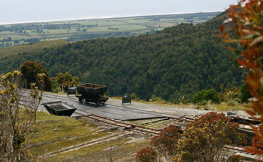
The Denniston historic place, approximately 29km north-east of Westport, has operated as a coal mining area since the 1870s and is one of New Zealand's most significant industrial sites. The famous incline, which from 1880 to 1967, delivered large volumes of high quality coal down a precipitous slope to the rail head below, was widely referred to as the 'eighth wonder of the world' because of its length, gradient and the volume of coal it carried. In 1990 New Zealand's Institute of Professional Engineers (IPENZ) placed a plaque at the top of the incline acknowledging it as one of the 50 most important historic engineering achievements in the country. The machinery from the closed incline has gone, but the route it took is apparent and some relics remain. Throughout the historic place there are also many other remnants of machinery and foundations of buildings which tell the story and represent the technology used in this once busy mining operation. The methods of extracting coal followed contemporary practices as did systems of transporting the output from the mines to the top of the incline. At Denniston, however, adaptations were necessary to cope with the physical conditions. The well designed and skilfully constructed stone Banbury Arch bridged a gully to provide tramway access to the original mine. Cornish stone masons responsible for the bridge also made a number of fine stone walls in the area with an especially imposing group around the brakehead at the top of the incline. The mines' associated settlements have a unique social history because of their location in this isolated and desolate place on the exposed edge of plateau 600 metres above sea level. The primitive nature of the early housing reflects the privations endured by the first workers and their families. Residents' effort to make their confined lives more pleasant is found in their provisions for sports and leisure with the sites of tennis courts, recreation grounds, and swimming baths etc. still identifiable. Today Denniston itself is a ghost town with a handful of residents where over 800 people once lived. Only remnants of houses and other building survive in the other settled areas. It was a hard life for workers in and around these mines and there was frequent conflict with management through their efforts to improve conditions. A significant feature of Denniston's history was the formation of the first formal coal miners' union here in 1884, an action which encouraged the establishment of further unions through New Zealand. There were strong links between the activities of this union and the formation of the Labour Party.
Location
List Entry Information
Overview
Detailed List Entry
Status
Listed
List Entry Status
Historic Place Category 1
Access
Able to Visit
List Number
7049
Date Entered
4th April 1995
Date of Effect
4th April 1995
City/District Council
Buller District
Region
West Coast Region
Extent of List Entry
The historic place is part of the large Denniston coalfield on the Mt Rochford Plateau, east of Westport. Since the 1870s many mines have been worked to extract coal from the rich deposits which extend along the Papahaua Range. The original Denniston mine, located some 600 metres above sea level, was one of the first on the plateau itself and the historic place encompasses the nucleus of its operations and the mining activities that followed. There is no physical feature to define the boundary for the area but it is described below and is indicated on the Map of Physical Extent of Registration in Appendix 1. The area's boundary runs from the base of the incline to the centre of activities at the brakehead and then continues along the route to major mining areas at Burnett's Face and Coalbrookdale. It includes features which are representative of the unique history of this mining locale. Included within the area are places of technological and historic significance relating to the mining operations which have taken place here since 1878. These include remnants of the site's most famous feature, the incline, and the other transportation systems which brought coal from the various mines to it. The social history of Denniston has been well recorded and many places and items remain to tell its story. Elements of the various townships remain at 'The Camp', Denniston, Marshallvale, Burnett's Face and Coalbrookdale. Apart from remains of dwellings, the sites of commercial or public buildings or recreational activities can be identified to gain a picture of the life settlers evolved for themselves. The Department of Conservation has already placed a number of well illustrated interpretation panels around the area and plan to add more to tell the full story of Denniston's past. Remaining roads and tracks contribute to the history and link the various components. Extent includes all remnants relating to Denniston. The key components are: the self-activating rail incline; Neighbours Brickwork Site; the former Bridle Path (now walking track); the brakehead and stone retaining walls; the Banbury Arch, mine mouth and rail link; the roperoad; the lower aerial tower; the bath houses and former power house chimney base; the settlements; and the Coalbrookdale Mine site and Fanhouse.
Legal description
Secs 1, 2, 5, 6, 8, 13, 21, 22, 27, 30, 32, 35, 38, 39, 40, 41, 44, 45, 46, 47, 48, 49, 51, 52, 53, 54, 57, 58, 62, 64, 65, 72, 77, 79, 80, 83, 87, 94, 97, 100, 103, 104, 106, 107, 111, 115, 122, 123, 124, 142, 143 Town of Denniston (RTs NL13/97, NL14/43, NL6A/687, Identifier: 216495, NL14/44, NL1A/270, NL92/57, NL1B/842, NL42/36, NL13/232, NL13/235, NL10A/1277, NL13/236, NL13/237, NL8C/367, NL13/239, NL14/181, NL13/98, NL2B/78, NL9A/989, NZ Gazette 1964, p. 1594, NZ Gazette 1975, p. 189, NZ Gazette 1979, p. 700, NZ Gazette 1982, p. 3696), Pt Secs 26, 28, 36, 41, 44, 45, 50, 59, 60, 61, 66, 67, 68, 69, 73 & 74, 82, 87, 89, 90, 91, 96, 101, 102, 127, Town of Denniston (RTs NL13/210, NL8C/1350, NL39/191, NL33/90, NL7C/34 & NL45/56, NL125/14, NL22/60 & NL22/59, NL 84/72 & NL14/77 & NL84/73, NL35/260, NL11D/43, NL20/89, NL50/232, NL54/39, NL9A/746, NL14/51, NZ Gazette 1972, p. 500, NZ Gazette 1975, p. 189, NZ Gazette 1982, p. 3696, NZ Gazette 1987, p.1248), Sec 75, Blk V Kawatiri SD, (NZ Gazette 1976, p. 2287, NZ Gazette 1979, p. 700), Secs 7, 11, 40, 44, 45, 47, 50 and Pt Sec 42, Blk VI Kawatiri SD, (RTs NL89/13, NL55/139, NL5C/6, NL11B/157), Lot 1 DP 542 (being Pt Sec 66 Town of Denniston) (RT NL39/95), Lots 1, 2 DP 61 (being Pt Sec 81 Town of Denniston) (RT NL16/70, NL16/69), Lot 2 DP 1987 (being Pt Sec 89 Town of Denniston) (RT NL68/279), Secs 1, 2, 3, 4, SO Plan 14864 (RTs NL10A/333, NL10A/582, NL10A/573, NL10A/574), Sec 1 SO Plan 14928 (RT 10A/1303), Sec 1 SO Plan 15088 (RT NL11A/1123), and all SO Plans 3524, 8550 and 10411 (NZ Gazette 1979, 700), all Kawatiri SD, Nelson Land District. (Further information is provided in Appendix 1 of the registration report.)
Location Description
Denniston is located 9km from Waimangaroa which is 16.5km east of Westport on State Highway 67, the route north towards Karamea.
Cultural Significance
Social Significance or Value: It was the stark, isolated location that made the settlements at Denniston unique, resulting in the development of a special community spirit of endurance, acceptance and enterprising action. Their determination to improve their life style through establishment of leisure and sporting activities with the necessary facilities can be illustrated by just one example, when truck loads of soil were brought up to the rocky plateau to create a bowling green. Denniston was perched at the edge of a cliff from which spectacular views are possible, but at the same time conditions in the harsh environment were so demanding that the views were only a minor and infrequent solace. Plentiful records are available to provide an understanding of the hardships endured and the efforts made to create a more comfortable and enjoyable life. Residents were proud of their mine's impressive production of prime quality coal and of the marvellous incline. There was a small sense of rivalry among the residents of the differing communities, usually of a friendly nature, though sometimes there were minor political or religious differences. Together the united workers continually sought fairer, safer, better-paid working conditions, while management resisted.
Historic Significance
Historical Significance or Value Denniston holds a major place in the history of the coal mining industry in New Zealand through the sustained quality and quantity of its output and the special features associated with its operation. The first mine to operate from the Buller coal plateau, it led the way for others to open in this rich field. The technological ingenuity of its incline transport system demonstrated that it was economically viable to mine coal from such an inaccessible location. Despite nearly 140 years of efficient mining of the Denniston field, sufficient resources remain for further programmes to be considered through extraction by modern methods. Throughout New Zealand the mining settlement at Denniston has been known because of its impressive production of high quality coal, the extreme nature of the incline, the desolate living conditions of the workers and their families and its role in the development of coal mining unionism. The place has been associated with many nationally important people like Sir Julius von Haast, who initially surveyed the site and John Lomas, who played a major role in the development of unionism. William Larnach was one of the founding shareholders and directors of the original company and over the years the various managers have had a significant impact both on the mining systems and the lives of the workers. The relationship between management and workers in Denniston was fraught from the earliest days, resulting in this being an important chapter in the history of unionism and the founding of the Labour Party.
Physical Significance
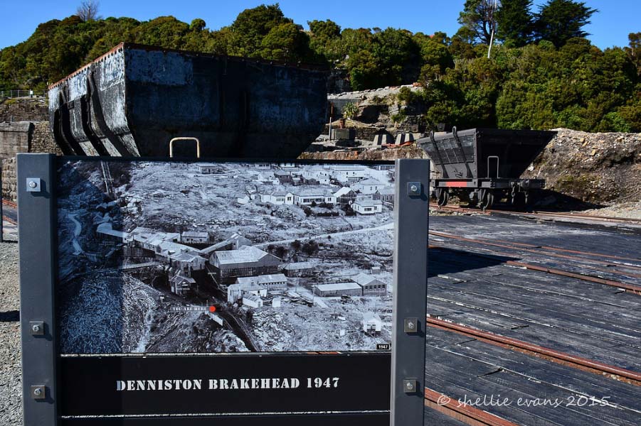
Archaeological Significance or Value: The whole of the area within the boundaries of the historic place comprises a single archaeological site where many places are known and others have potential for investigation. There are numerous archaeological sites throughout the area. Although none are registered, their significance is recognised by the principal owner the Department of Conservation and also by the Buller District Council. This is also true for Solid Energy which has interests in places where there are sites beyond the boundary. While most sites relate to aspects of mining activity the settlement areas have important archaeological values, as the living conditions here differed from others of similar date because of the unusual environment. Technological Significance or Value: The mining activities in the area demonstrated a number of both representative and special features of technological significance. Few of the systems were unique. While horse drawn and steam powered tramways, double cabled continuous roperoads, aerial ropeways and self-activating inclines were used in other places, the particular geographical location and terrain of the Denniston mining field called for ingenious adaptations and solutions. The incline itself, popularly called 'the eighth wonder of the world', was world renown because of its length, the volume of coal it carried and its gradient. In comparison with other similar inclines that operated on the Buller coal plateau the Denniston incline functioned for a longer period, its length was greater and it descended a steeper, more precipitous escarpment. (Neighbouring Millerton's incline had the distinction of passing through a short tunnel.) The very efficient systems associated with the use of the incline ensured the most rapid transfers and delivery of coal from the mine to the port. Extensive lengths of stone wall remain at Conns Creek and the brakehead and these, along with the Banbury Arch, illustrate the skill of the Cornish stone masons who worked here. They were probably also responsible for the stone retaining walls alongside the roperoad cuttings, and lining the creek banks. The stonework is a special feature of these sites.
Detail Of Assessed Criteria
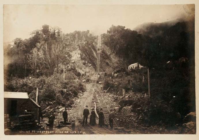
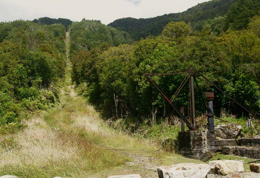
a) The extent to which the place reflects important or representative aspects of New Zealand history: The discovery of coal and the setting up of a major mining industry at Denniston in the Buller region of the West Coast is an important representation of the initial developments that contributed to the successful colonisation of New Zealand. The country's governing bodies were eager to discover what mineral resources were available in their new land. Nelson Provincial Council sent surveyor John Rochfort in 1859 and geologist Julius von Haast in 1860 to follow up reported sitings of coal in the Buller region. Their discoveries identified the potential for extensive coal extraction and small operations that were soon established were assisted by the development of a port at Westport and construction of a railway linkage along the coast. These amenities also supported the huge mining operation on the plateau at Denniston that developed as a private initiative. This place represents the roles of government, individual investors, skilled professionals and workers in the establishment of an early industry extracting the country's mineral wealth. b) The association of the place with events, persons or ideas of importance in New Zealand history: The establishment of workers' unions throughout New Zealand in the nineteenth century was an important event in the nation's social and political history. The particular extremes of conditions for workers at the Denniston mines ensured that this was a place where unionism developed rapidly and strongly. The Denniston Miners' Mutual Protection Society formed in 1883 was one of the principal founding bodies in New Zealand. It was an example to other miners on the West Coast and beyond, and these organisations soon developed close links with the recently established Labour Party. These political activities are a significant feature of Denniston's history. John Lomas, a skilled miner from Yorkshire, was president of the union. He soon developed a joint organisation bringing together all West Coast miners and rapidly became one of the foremost union leaders in New Zealand. His role was a key one in the evolution of unionism. c) The potential of the place to provide knowledge of New Zealand history: The physical remnants of the machinery associated with the mining activities are just some of the features which tell the story of the Denniston Mines' history. These, along with the numerous structures - the incline, bridges, stone walls and embankments, etc - provide an understanding of the vast industrial operation that was carried out here. There is considerable evidence of the townships that once covered the various sites and these illustrate the place's past with its group of once bustling communities. Denniston's history has been extremely well documented with written and photographic records. Many archaeological sites have been recorded to date and there is potential for a vast amount of further archaeological work to be undertaken. e) The community association with, or public esteem for, the place: Despite being a small and remote West Coast place, Denniston is a name known to many New Zealanders because of the widespread fame of the remarkable Denniston Incline. People recall the outstanding engineering achievement of the incline and the difficult life style of Denniston's residents. The town has an almost iconic status in New Zealand history. The recently published novel, The Denniston Rose, by Jenny Pattrick has introduced more people to the Denniston story. A small group of locals, assisted by former residents and their descendents, have formed a society, 'The Friends of the Hill', demonstrating their association with Denniston and the high esteem in which it the place is held. The Department of Conservation, which manages the site, also recognises the place's overall significance and appreciates the wider population's great interest. f) The potential of the place for public education: Denniston, as the site of a major mining endeavour and of early housing settlements, has important educational values with much that illustrates features of historic industrial activities and the lifestyle of the people involved. The place has reserve status and is open to the public. The 'Friends of the Hill' collect records and have set up a small museum to educate the increasing number of visitors. Existing information panels are broad ranging and of excellent quality. There is potential for provision of further public educational features as the place has numerous tales to tell. Work by the Department of Conservation is currently underway to supply these. With the ease of accessibility to the site, visitors can gain an understanding of the complex technological problems the early miners faced and the means they employed to overcome them. They can readily learn about the harshness of living conditions that the nineteenth and early twentieth century residents endured in the stark, rocky environment often assailed by severe weather. g) The technical accomplishment or value, or design of the place: The technological achievements of the men who began mining activities at Denniston in 1879 were remarkable. Packhorse delivery of coal by a tortuous track to the rail head at Waimangaroa was the slow and uneconomic system used until the self-activating, cable operated incline was completed in 1880. This proved an extraordinary success because of its efficiency in rapidly transporting vast quantities of coal. It has been hailed as an outstanding engineering achievement since it began operating and in 1990 IPENZ (the New Zealand Institute of Professional Engineers) installed a plaque at the top of the incline identifying it as one of the 50 most significant engineering feats in the country. The stone features, the incline, and other mining and transporting techniques used at Denniston illustrate the outstanding technical values of the place. j) The importance of identifying rare types of historic places: Denniston is a rare historic place in many ways. The self-activating cable operated incline was a rail transporting system that was used frequently, but this example had special features. It was of greater length (1.7 kilometres) and descended further (518 metres) over a steeper, more precipitous cliff face than other inclines on the plateau. Its output was also larger and it functioned over a longer period. Overall the difficulties of mining this area were greater than on other New Zealand sites. The workers who operated the mine lived in a stark, unforgiving environment which has established stories of their lifestyle as a renowned part of New Zealand's social history. The establishment of permanent townships on such an inhospitable site with extreme difficulty of access to the exposed plateau and its severe weather conditions is rare in New Zealand. k) The extent to which the place forms part of a wider historical and cultural complex or historical and cultural landscape: The Denniston historic place encompasses an area that includes the heart of the mining operation that functioned here. It includes the incline's route from the rail head at Waimangaroa, the main brakehead area where coal was stored and dispatched, the routes to the mine openings and the various settlements. Although these features are the key elements, they are just part of the much larger expanse of this section of the plateau which was mined and serviced by the incline. They are a major component of the wider Denniston historical landscape. The place also forms part of the extended landscape along this plateau where coal mining has been a crucial West Coast industry that continues today. Summary of Significance or Values: Denniston merits registration as a Category I (one) historic place because of its special or outstanding heritage or cultural significance or value. It meets the following criteria: a, b, c, e, f, g, j and k Conclusion: It is considered that this place qualifies as a Category I historic place. Denniston is a place of outstanding heritage significance because of its history as an early major coal extracting industry that succeeded through use of its remarkable self activating, cable operated incline. The technological achievements of the men who began mining activities at Denniston in 1879 were remarkable. The stone features, the incline, and other mining and transporting techniques used at Denniston illustrate the outstanding technical values of the place. Its inaccessible and inhospitable location, which made the lives of those who lived and worked there miserable, has given it a special place in New Zealand history. The environment and working conditions encouraged the early development of unionism, an important feature of New Zealand's past. It is readily accessible to visitors and provides exceptional opportunities for public education.
Construction Professional
Biography
H.W. & R.A. Young (Young Bros.) were Scottish-born engineers based in Westport. in the late nineteenth century.
Name
Young Bros.
Type
Engineer
Construction Details
Description
Stone arch bridge (Banbury Arch) built
Start Year
1878
Type
Original Construction
Description
Denniston settlements
Period
From 1879
Type
Original Construction
Description
Fixed arm water powered hydraulic crane at Incline
Start Year
1904
Type
Addition
Description
Old Power House
Period
1920s
Type
Other
Description
New accommodation provided for workers at Marshallvale
Start Year
1924
Type
Addition
Description
New Bath House
Start Year
1940
Type
Addition
Description
Lower Aerial tower
Finish Year
1954
Start Year
1950
Type
Addition
Description
Incline completed
Start Year
1880
Type
Other
Description
New bridle path formed
Start Year
1884
Type
Addition
Description
Roperoad transportation system constructed
Start Year
1887
Type
Original Construction
Description
Coalbrookdale and Iron Bridge Mines in full operation
Start Year
1889
Type
Other
Description
Neighbours Brickworks Site
Start Year
1893
Type
Other
Description
Road constructed to the plateau
Finish Year
1902
Start Year
1901
Type
Addition
Construction Materials
Stone, brick, steel, concrete, iron (including corrugated iron), timber, and tin.
In pre-European times Maori travelled along the Papahaua range in Westland and through the coal plateau, but the mineral was of little interest to them as they made no use of it. Heaphy and Brunner, exploring the West Coast in 1849, noted a coal seam in a small stream near the Nile River south of Westport. In 1859 the Nelson Provincial Government, keen to understand the potential for usage and settlement of the West Coast, employed John Rochfort to lead a survey party to the area. During his abbreviated trip he noted two coal seams in the banks of the Waimangaroa River. The government next commissioned the German geologist Julius von Haast to undertake a geological survey of the Buller region with the discovery of coal of prime interest. The party which included colliery engineer James Burnett, set off in February 1860. When an impressive coal seam was discovered in a valley in the headwaters of the Waimangaroa River, Haast named the area Coalbrook Dale after an English coalmining village and the rocky bluff above it was called Burnett's Face. The peak above the plateau was named after John Rochfort. Haast's diary described this seam as 'eight feet two inches of pure coal' and he estimated that the coal field extended 'over an area eight miles in width and fifteen miles in length'. In today's measurements this equates to a seam of coal 2.5 metres thick and an area that covered 12.9 by 24.14 kilometres. Samples analysed in Nelson proved the coal had high carbon content and was of world class quality. The Nelson Provincial Government, still hopeful of finding gold as well as coal, sent a further exploration party to the Buller region in 1862 to advise on development of a port in the region. James Burnett and John Rochfort who were included in the party made more detailed surveys of the coal resources and Burnett's report stated that there were commercial quantities of readily workable coal. Westport was considered the best place for a port and Burnett at once pondered the problem of transporting coal there for shipment. Rail was the obvious means and he proposed construction of a self acting incline for the descent from the plateau. Some small mining operations on the lower slopes were established here over the following years while work on developing the port at Westport proceeded. Construction of the Mt. Rochford railway commenced northwards along the narrow plain, eventually concluding at Seddonville. It reached Waimangaroa on 5 August, 1876 where a branch line extended up the lower section of the Waimangaroa River Gorge to the site of a small mining company's operations. Meantime Robert Blair Denniston had surveyed and assessed the plateau fields and interested a group of wealthy Dunedin business men, including William Larnach , in extracting coal from this area. In 1878 the Westport Colliery Company was formed with a capital of £100,000. The company secured Coalbrookdale leases of over 2450 acres (991.5 hectares) from the New Zealand Government for a period of 91 years. By 1879 mining had begun at the Fisher Mine, later known as the Banbury Mine, with coal brought down to the railhead by packhorse. The construction of the self acting, cable operated incline, as Burnett suggested, was already underway. The company engaged the engineering firm Young Brothers to design and manage the construction project. The Scottish born engineers were based in Westport. They worked with local contractors Day and Blair. Arrangements were made to employ 50 experienced British miners who had arrived with their families in Nelson late in December 1879 to find that the company did not yet have work for them. With completion of the incline in April 1880, the first load of coal was transported to the rail head, now extended to its base and production was able to get underway. Output was small and not very profitable at first. The company was restructured in 1881 as the Westport Coal Company Limited under the same directors but with a quadrupling of the capital. By 1882 production had doubled with 50,000 tons (50,802 tonnes) extracted and dispatched down the incline. By 1882 the Banbury Mine had driven through to Burnett's Face and coal was being mined from several places in the vicinity. Initially it was transported back to the rail head through the mine shaft, but in 1887 a surface roperoad haulage system was established. Two years later the Coalbrookdale and Iron Bridge Mines were in full operation with the exported product, marketed as Coalbrookdale coal, eagerly sought because of its acknowledged quality. Its reputation was enhanced following the widespread story of the British warship H.M.S. Calliope being the only vessel to have sufficient steam power through its use of Coalbrookdale coal to speed from disaster during a hurricane in Samoa in March 1889. The Royal Navy became a major customer ensuring it had Coalbrookdale coal available for its vessels around the world. In 1895 Denniston was the largest producer of coal in New Zealand with an output of 215,770 tons (219,232 tonnes) for the year. The peak year of production was 1910 when the output was 348,335 tons (353,925 tonnes). The workers at Denniston first lived in tents on a narrow hill side ledge close by the Banbury mine. In those early days canvas was the most easily transported material to provide shelter in this inhospitable environment and the small settlement was known as 'The Camp'. With the incline coming into use in 1880 the transportation of timber and other building material improved the situation for the increased numbers living in The Camp and the settlement around the brakehead at the top of the incline. The company provided a number of houses which were rented to workers. Tales of the stark living conditions for Denniston workers are legend, illustrated by the experiences recorded by many. When Tyneside miner Nicholas Milligan brought his wife and two children to the hill in 1883, Maria chose to live in a tent at The Camp rather than share space in a rough slab hut with a group of bachelors. They lived there for the next six years during which four more children were born, coping with the most primitive conditions in the trying climate. Maria did not go down the hill for 14 years. Many other settlers were similarly reluctant to attempt the journey to and from the plain. There was only a very rough track up to Denniston from Waimangaroa and the alternative pedestrian route was alongside the incline. In 1884 the situation improved when a more manageable bridle path was formed. Before this, the incline wagons often carried passengers, a practice that continued even after the company attempted to ban it because of the inherent dangers. At best it was described as a 'thrilling' experience but for many it was so terrifying they had no wish to repeat it. The population increased as further mine workings opened and the settlements spread beyond The Camp and Denniston to Burnett's Face and Coalbrookdale where the severe weather conditions were lessened in the more sheltered valley settings. Denniston remained the pre-eminent centre but a good range of facilities were established in each place - shops, hotels, theatres etc. By 1902 a road was constructed to the plateau and in the following years more services were provided to make life less harsh. Denniston workers were always enthusiastic supporters of the leisure and sporting activities available to them. The Brass Band was successful and highly regarded and rugby was played on one of the hardest grounds in the country. The rocky ground prevented residents from attempting to beautify their surroundings or making gardening a hobby. It also meant that it was not possible to create a cemetery on the hill and many residents made their final journey down to Waimangaroa in a coffin on the incline. For many the benefits outweighed the negatives and later residents often recall Denniston as a happy place of fun and jollity. From the earliest days of production at Denniston, managers were wary of employing British miners who might bring with them ideas of radical unionism. Relationships did not begin well with the arrival in Nelson of the British migrant workers in 1879 when work was not yet available. The company manager, Arthur Burns, was unsympathetic, unhelpful and distressed to learn that those selected were of non-conformist religion and therefore in his eyes, inevitably trouble makers. Mistrust on both sides was the result, as it was essential for Burns to employ workers with experience and it was not only the skilled migrant miners who rapidly expressed concern over their conditions of employment. John Lomas, who played a major role in the development of unionism in New Zealand had arrived with the group of migrant miners in 1879 but did not come to Denniston until 1883. In September that year he was elected president of the Denniston Miners' Mutual Protection Society, which was the real beginning of mining unionism in New Zealand. Much bitter conflict ensued over the following decades between managers and workers, 'them and us', and this has continued for over a century. The Denniston Union inspired the formation of unions in other mining areas and was closely allied with the newly formed Labour Party. Management's immediate response to the union's formation was to reduce the rates for hewing coal. This led to a strike and lockout that lasted six months. The workers had the final victory after severe suffering that was compounded by the isolation and management's restrictions - no access to coal for fuel and no use of the incline for transportation of supplies. Conflict continued with major strikes or lockouts in1890, 1913, 1923 and 1921. A good output was achieved over the early years of the twentieth century and in 1924 new accommodation for workers was provided by management at Marshallvale a short distance inland from Denniston. By this time with an improved road and easier transport systems, some workers chose to live in Waimangaroa and make the daily journey up the hill. This process increased during the 1930s depression years and the population declined, with some people shifting their houses down to the plain. In 1948 with the Nationalisation of Coal Mines Act the government purchased the assets of the Westport Coal Company. Improved systems reduced the number of workers and by 1950 the population had reduced to 500. Within a decade Burnett's Face and Coalbrookdale were deserted and Denniston's numbers were declining fast. The closure of the remarkable incline in 1967 marked the end of a significant era in New Zealand's industrial history. In its 87 years of operation it had transported 12.6 million tons (12.8 million tonnes) of coal. Road transport efficiently took over, with trucks carrying coal directly from the mines to the Waimangaroa rail yards. Operations continued with new mines being opened as the older ones within the historic area boundary were worked through. New systems like hydraulic mining were introduced with coal being blasted from the seams and then pumped out to surface bins. The Denniston coalfield is now a quieter place with production only from the privately owned mines like the Cascade Mine beyond Burnett's Face. These are outside the boundary of the historic place, though coal trucks travel through it. 1. Name: Denniston Incline [DoC map, Nos.3-6] Address:Denniston Mine area Legal Description: Pt. Sec. 44 Block VI Kawatiri Survey District, Pt. Denniston Scenic Reserve, NZ Gazette 1979, p.700 Owner(s):The Crown. Public Conservation Land, managed by Department of Conservation. Address of Owner(s): Department of Conservation, West Coast Conservancy, Private Bag 701, Hokitika New Zealand Archaeological Association No. Recorded site K29/54 (rail yard). K29/55 (incline railway) Self activating rail incline, 1880-1967 Engineer: Young Brothers, Westport. Builder: Day and Blair There was a considerable time delay from the discovery in 1859 of the huge coal deposits in the Papahaua Range north of Westport until the coal could be commercially extracted. It was recognized by James Burnett during his 1862 survey of the site that transportation of the ore down the escarpment was the greatest issue in establishing a viable commercial operation on the plateau. He suggested the use of a cable operated incline on which empty wagons would be returned to the top by the descent of the heavy loaded ones. This was the system which was used from 1880 to 1967, a remarkable engineering achievement, described by proud locals as the 'eighth wonder of the world'. The line extended from the facing edge of the plateau where the township of Denniston developed, to Conns Creek near Waimangaroa on the narrow plain below. Construction of the Denniston Incline began in 1878, the first project being provision of a bridge over Conns Creek near the incline's base. Higher up the slope a further bridge and sections of timber viaduct were required for the track to ascend the steep grade to the coal plateau by following as straight a route as possible. Eighteen kilogram rails were laid in the standard 1.16 metre gauge. The incline was in two sections with the gravity operated wagons, controlled by a four inch (10.2 cm) steel wire rope travelling a single track to the Middle Brake, 33 chains (664 m) from the top where a double track enabled full and empty wagons to pass. At this point a separate cable controlled the wagons on the lower section. Over the 83 chain (1.7 km) length of the track the fall was 1700 feet (518 m) with some grades as steep as 1 in 1.25. To provide a carrying capacity for loaded wagons weighing up to 12 tons (12.2 tonnes) an effective braking system was essential. 'The braking system adopted resembled a direct-acting horizontal winding engine, but the action was directly opposite. Water was used to check the action of pistons instead of steam to give them motion. The water was drawn off at each stroke and replaced by a fresh supply as the severe pressure would raise it to boiling point. There was also a very effective strap brake around the raised centre of the drum that could be used in emergency or when bringing a load to a stop. It could be wound up tight by the brakesman for this purpose'. On 24 October, 1879 a public holiday was declared in Westport with a special train taking passengers to Conns Creek so that they could walk up the incline for the ceremonial driving in of the last spike at the top. The occasion was celebrated with a ball in Waimangaroa. To complete the transportation system, bins and screens were built at the Brakehead, the horse tramway to the Banbury mine coal face was constructed and in mid-April 1880 the first load of coal descended the incline. The incline itself was now the principal access to and from Denniston for freight and people, with tales of the terrifying nature of this journey spreading immediately. There were many instances of accidents occurring and wagons being derailed, leading the company to officially forbid riding on the wagons in 1885 by which time a bridle path/foot-track was in place. Over the following decades efficiency improved so that by the 1950s over a thousand tons a day was delivered into a hundred wagons for delivery to the port making Westport the busiest coal exporter in New Zealand. Rail to Lyttelton was possible from 1953 when the link to Reefton through the Buller gorge was completed. The incline continued operating until 16 August 1967, having carried some 12,600,000 tons (12,802,191 tonnes) of coal down to the railhead in the wagons which travelled at speeds up to 80 kilometres an hour. The closure followed a decline in the demand for coal in 1965. This was accompanied by increased costs for employing the labour force managing the incline and difficulties finding replacements for the 'Q' wagons which had been such a successful feature of the incline's use. Road transport replaced the old system and on 24 May 1968 the Inangahua earthquake caused major damage when a huge rockfall buried the upper part of the incline. Many of the structures were removed for scrap metal or to ensure safety, yet enough features remain for an understanding to be gained of the 'wonder' of this engineering achievement. Only remnants of the original track, its bridges and viaduct survive and it is overgrown in parts. Viewpoints are available from its base at Conns Creek, from Middle Brake and the Brakehead, or its route can be followed along the Bridle Path track. Alongside the track, remnants of broken wagons testify to the dangers associated with this transport system. About one third of the way down at the Middle Brake, where the loaded and empty trucks passed on the double track portion, brake cylinders remain on the foundation of the level concrete platform. There are also an old hut, a boiler, some elements from a winch, a points lever and the Sampson brake which was used for lowering wagons from the upper incline to the lower section. The foundation of the top brake remains at the upper termination of the incline. At the base, the current access road to the Conns Creek marshalling yard follows the route of the railway which linked the incline to the Waimangaroa branch line. Stone walls are a key feature here bracing the shallow rail cutting and the sidings at the incline's base. The walls are particularly well built and generally in good condition. They were constructed by Cornish stonemasons using stone quarried in the vicinity. Building foundations remain in the yards and two 'Q' wagons are sited on a remnant of the railway line. Ordinary NZR wagons were first used to transport coal down the incline, then for a period the 'O' class wagons with a fixed hopper improved efficiency. The distinctive 'Q' wagons were first introduced on the incline in 1897. Made at Greymouth, Westport and Addington to designs by the Greymouth Harbour Master, they were used at a number of West Coast coal mines to facilitate and hasten the transportation of coal. At Denniston the wagons were loaded at the top of the incline, descended to Conns creek and transferred directly onto the rail line where they were transported to Westport. Here the steam cranes at the port could lift the wagon's 12 tonne weight and deliver the coal through the hopper in their base directly into the ship's hold. This was an extremely efficient system which can be seen as a forerunner of containerisation. A fixed arm, water powered hydraulic crane, c.1904 remains in place. It is largely intact but no longer functional. Of steel and timber construction on a concrete base, the crane was used to load goods onto the empty 'Q' wagons for delivery to the top of the incline. DoC has recently undertaken restoration work on the incline. 2. Name: Neighbours Brickworks Site [DoC map, No.99] Address: Denniston Mine area Legal Description: Pt. Section 44 Block VI Kawatiri Survey District. Pt. Dennis-ton Scenic Reserve, NZ Gazette 1979, p.700 Owner(s): The Crown - Public Conservation Land, managed by Department of Conservation Address of Owner(s): Department of Conservation, West Coast Conservancy, Private Bag 701, Hokitika New Zealand Archaeological Association No. Not yet specifically recorded. William Neighbours, an experienced brick maker from Middlesex, first came to Christchurch in 1858 where he established a brickworks in the early 1870s before moving to the West Coast. He and his sons set up several brickworks here and later in Nelson. The Waimangaroa Brickworks, established 1893, was a thriving concern producing bricks and pipes for Denniston as well as the wider Buller district. Until the 1960s, production continued from this convenient location close to the rail way and local sources of good clay. Vast quantities of bricks for use in the mine industry and the various settlements were transported up the incline from this conveniently placed source. The site of what was a significant industrial complex closely associated with Denniston's history is now overgrown. Today, the remnants of the chimney and kiln are disappearing with ongoing removal of the bricks by public pilferers. 3 Name: The former Bridle Path, now walking track [DoC map, No 2] Address: Denniston Mine area Legal Description: Pt. Section 44 Block VI Kawatiri Survey District. Pt. Dennis-ton Scenic Reserve, NZ Gazette 1979, p.700 Owner(s): The Crown - Public Conservation Land, managed by Department of Conservation Address of Owner(s): Department of Conservation, West Coast Conservancy, Private Bag 701, Hokitika New Zealand Archaeological Association No. Recorded site K29/56 (bridle track) In 1884 the completion of a bridle path from Waimangaroa on the plain to Denniston on the plateau brought cause for celebration by those living on the hill. An uneven winding track laboriously cut into the steep stony hillside, it still meant a strenuous climb for pedestrians but was infinitely preferable to struggling up the incline or experiencing the dangers of riding up or down in one of the wagons. Completion in 1902 of what is now the access road, eased the transport situation even further as it allowed workers to begin to shift from the hill and reside at Waimangaroa, making the journey to the plateau daily. The original bridle path route is now maintained by DoC as a walking track which offers magnificent views and provides access to the Middle Brake via a branch track. This branch follows the route of a pipeline that supplied water from upper Conns Creek to the brake system. 4. Name: The brakehead and stone retaining walls. [DoC map, No.6 ] Address: Denniston Mine area Legal Description: Pt. Section 44 Block VI Kawatiri Survey District. Pt. Dennis-ton Scenic Reserve, NZ Gazette 1979, p.700 Owner(s): The Crown - Public Conservation Land, managed by Department of Conservation Address of Owner(s): Department of Conservation, West Coast Conservancy, Private Bag 701, Hokitika New Zealand Archaeological Association No. Recorded site K29/58 (brake head) The machinery for the braking system was located at the head of the incline. This was where the loaded wagons were dispatched on their downward journey, the upcoming empty ones refilled and those bringing up freight or passengers unloaded. This location at the edge of the plateau was a hub of activity over the years of the incline's operation. It was the terminus for the various systems which brought coal here - rail lines, an aerial ropeway and a roperoad. The coal was stored and screened in huge bins of which only foundations remain. The dominating remaining physical feature is the cluster of massive stone retaining walls which were built to create a series of level terrace areas on which the various buildings and structures were located. The walls built from cut blocks of ganister stone quarried on site were constructed by Cornish stonemasons. The skills of these craftsmen are attested by the survival of the walls here and at Conns Creek after nearly 130 years. Clearance of the site has left few reminders of the past though the Department of Conservation's interpretation panels provide a vivid impression of the site's original use and appearance. Re-usable items and scrap metal elements were removed and many relics were simply bulldozed over the site's steep edge. A chimney base, slack heap and foundations of the bins, brake-house, carpenter's shop and workshop can be identified. Near the edge of the slope where a massive rock fall resulted from the Inangahua earthquake, 24 May 1968, some of the steps which gave access to the manager's office remain. Two aerial ropeway return wheels and a cable tensioner are retained and two further 'Q' wagons are sited on a section of rail track. In 2007 the brakehead was restored by the Department of Conservation. 5. Name: The Banbury Arch, mine mouth and rail link [DoC map, No.14] Address: Denniston Mine area Legal Description: Pt. Section 44 Block VI Kawatiri Survey District. Pt. Den-niston Scenic Reserve, NZ Gazette 1979, p.700 Owner(s): The Crown - Public Conservation Land, managed by Department of Conservation Address of Owner(s): Department of Conservation, West Coast Conservancy, Private Bag 701, Hokitika New Zealand Archaeological Association No. Not yet specifically recorded. The 'Banbury Arch' is the name given to the stone arch bridge built in 1878 to give access to the entrance to the Banbury Mine, the first mining site commercially worked on the Denniston plateau. The bridge was designed by Henry and Robert Young, engineers appointed to the Westport Coal Company in that year. The mine entrance was beside a gully faced by a steep rock bluff. Extracting coal from this position was a difficult enterprise overcome by building a tramway over the bridge. Cornish stonemasons constructed the arch using ganister stone quarried on site. They formed the curve laying the lower course of blocks vertically with the courses above placed horizontally to provide the platform on which the tramway ran. The inner abutment was built into the bluff's rock wall. From 1878 coal was extracted from this mine, first known as Fisher's, and for an initial period was transported by pack horses down a rough track to Waimangaroa. Once the double track tramway was completed horse drawn wagons transported the coal some 800 metres to the top of the incline, where it was stockpiled for a period until the incline came into use in April, 1880. In 1883 an endless steam powered rope system replaced the need for horses on the tramway. The Banbury coal seams were soon exhausted and with the main tunnel being driven through to Burnett's Face by 1882 the focus shifted there. In 1886 the Banbury mine closed, with the tunnel continuing in use as a travelling and transportation route until 1904. Until recently the Banbury arch and entrance to the mine was overgrown and virtually hidden. In 2007 the Department of Conservation cleared vegetation to reveal a second smaller arch as part of the 'Banbury Arch' structure. Further work is continuing on the site so that visitors might follow a track to view the structure. 6. Name: The roperoad [DoC map, Nos. 26 &27] Address: Denniston Mine area Legal Description: Pt. Section 44 Block VI Kawatiri Survey District. Pt. Dennis-ton Scenic Reserve, NZ Gazette 1979, p.700 Owner(s): The Crown - Public Conservation Land, managed by Department of Conservation. Address of Owner: Department of Conservation, West Coast Conservancy, Private Bag 701, Hokitika. New Zealand Archaeological Association No. Not yet specifically recorded. The roperoad, also known as the skipway or haulage road, was a later transportation system constructed in 1887 to carry coal in bins (or 'boxes') along the plateau surface from Burnett's Face to the brakehead. It too was an endless rope conveyance powered by steam, with full and empty bins travelling to and fro along two tracks. The ropeway was extended to the Coalbrookdale Mine and the Iron Bridge Mine, both fully operational by 1889. With only a muddy walking track as access way, residents in the somewhat ramshackle Coalbrookdale and Burnett's Face settlements frequently preferred the quicker but dangerous option of walking along the roperoad in the period till 1891 when a road to Denniston was constructed. A frequently published photograph (refer Historical Photograph 8 in Appendix 2) illustrates the hazardous living conditions in a settlement bisected by the roperoad, where children played. Today a section of the DoC created walkway to Coalbrookdale follows the route of the old roperoad, providing an understanding of its formation through the terrain. At Burnett's Face foundations of the buildings associated with the roperoad remain and nearby is the entrance to a now collapsed tunnel which later took the trail through to the plateau and the brakehead beyond. It was at this point that bins were transferred to the main line from the linking side lines to the Coalbrookdale and Ironbridge Mines. The building in which 'shed boys' undertook the hazardous task of clipping bins to the moving ropes remains, but is in poor condition. Bare fingers were at risk of being trapped in the fast, clipping operation on moving bins and the danger increased in freezing temperatures. The building's surviving chimney for provision of a fire and warmth was an attempt to lessen the potential for bare fingers to freeze on metal. In 1904 a new roperoad was constructed from Burnett's Face to the brakehead, shortening the route through a tunnel, some deep cuttings and a steel viaduct. Greater power provided at this time meant greater loads could be transported and the level of production was increased. A number of features of the ropeway remain and its route can be determined, though the rails themselves have largely gone. In the section between Burnett's Face and Coalbrookdale there are many items including some bins and the remains of the stop start signalling system. There is another tunnel here and, near the mine entrance and its associated Fanhouse, the creek which runs alongside the ropeway track is crammed in places with large amounts of discarded wire rope. The sides of this creek again feature the skills of the Cornish stone masons with lengths of well constructed stone faced embankments. 7. Name: The lower aerial tower [DoC map, No.7] Address: Denniston Mine area Legal Description: Pt. Section 44 Block VI Kawatiri Survey District. Pt. Den-niston Scenic Reserve, NZ Gazette 1979, p.700 Owner(s): The Crown - Public Conservation Land, managed by Department of Conservation Address of Owner(s): Department of Conservation, West Coast Conservancy, Private Bag 701, Hokitika New Zealand Archaeological Association No. Recorded site K29/59 (Aerial route) The aerial ropeway, suspended from a series of steel towers, carried coal directly across the plateau from the Wharatea steps entrance (outside the historic area) of the Coalbrookdale mine to the head of the incline. Work commenced for this mono-cable haulage system in 1950 and it came into use in January 1954. It replaced and improved on the earlier roperoad system by following a more direct route and needing less manpower for its operation. Loaded bins were clamped to a moving rope. Aerial ropeways were used on various mining sites, a gravity operated bi-cable system introduced at similar date at the nearby Stockton Mine. The Denniston example which crossed a more level area required power from an electric motor. Along this route some remnants which remain are outside the proposed historic area. Representative of this efficient transport system are the return wheels at the brakehead and the lower area tower which has been the subject of maintenance and interpretation by the Department of Conservation. It occupies a prominent site by the road near the entrance to the Brakehead area and has two bins mounted as demonstration of the ropeway's function. 8. Name: The bath houses and former power house chimney base [DoC map, No.19] Address: Denniston Mine area Legal Description: Pt. Section 44 Block VI Kawatiri Survey District. Pt. Dennis-ton Scenic Reserve, NZ Gazette 1979, p.700 Owner(s): The Crown - Public Conservation Land, managed by Department of Conservation. Address of Owner(s): Department of Conservation, West Coast Conservancy, Private Bag 701, Hokitika New Zealand Archaeological Association No.: Not yet specifically recorded. The issue associated with the provision of bath houses for miners has been a major one in mining history and the development of the unions. The level of pay as well as conditions of employment were concerns that often caused tension, leading to the formation of the Denniston Miners' Union in 1884. After a long day's toil in the dirty and often damp conditions of the mines, workers trudged to their bathroom less homes to clean up in a tin bath in front of the fire, or to queue for the use of a wash tub at a boarding house. The building of bath houses, at the mouths of the Coalbrookdale and Iron Bridge Mines, by management was a concession towards improving conditions for the workers. There were reservations initially though, as workers believed they faced potential chills after bathing while walking home in the notoriously grim weather conditions of the plateau. In 1939 a new bath house replaced the earlier facilities. Its design was similar to one built at the same time for miners at Blackball. It was built beside the old powerhouse near Denniston and was used from 1940 to 1984 when an updated building was constructed This was appropriately named the John Lomas bathhouse commemorating the inaugural President of the Denniston Miners Union, a man who played a significant role in the development of New Zealand's Trade Unions. Most of the fittings have been removed from the largely intact structures. All that remains of the old power house, built in the 1920s, is the chimney base. The coal fired power house generated electricity replacing the steam power from a stationary engine for the operation of the transportation and other mining systems. 9. Name: The settlements Address: Denniston Mine area Legal Description: Pt. Section 44 Block VI Kawatiri Survey District. Pt. Dennis-ton Scenic Reserve, NZ Gazette 1979, p.700 Also, c.40 individual Town Sec-tions still in private ownership, many are abandoned land in process of be-ing transferred to Buller District Council ownership and others are re-serves for various purposes, e.g. police. Owner(s): The Crown - Public Conservation Land, managed by Department of Conservation. And others. Address of Owner(s): Department of Conservation, West Coast Conservancy, Private Bag 701, Hokitika New Zealand Archaeological Association No. L29 Map Sheet for Burnett's Face identifies house sites L29.25 to L2936 K29 map sheet for Denniston iden-tifies five mining related sites mentioned elsewhere. Denniston is the generic name used to include the various settlements which developed in the mining area. Today only seven houses close to the principal Denniston Town are left. In 1911 1500 people dwelled on 'the hill' and in each location just a few items, like foundations, steps or chimneys indicate where a house, school, hotel or shop once stood. Much has been written about the life led by residents here over the busy years between 1879 and 1867, of the conditions they endured and the provisions they made for themselves so that a happy life could be enjoyed. The settlements are as follows: a) The Camp [DoC map, No.10] The earliest workers pitched tents on a ledge in a narrow valley close to the Banbury Mine entrance. This gave rise to the name 'The Camp'. More permanent materials were introduced as timber was felled, corrugated iron was brought to the site and small rough cottages were constructed along this precarious site. They are described by Cecilia Adams as being constructed of 'corrugated iron and sheer necessity'. As mining activity increased so too did the number of workers living here within this cramped area without sanitation and running water. Within the heavy bush clad area only a few fragments of these primitive and often flimsy buildings and some steps remain as evidence of the first settlement. A track runs through the area. b) Denniston township [DoC map, No.11] The township was named for Robert Denniston who first recognized the potential of the area. By 1880, as the population expanded, settlement developed from The Camp to the small level cliffside area at the top of the incline. In 1885 a surveyed plan for the 'Town of Denniston', including The Camp, was drawn up and by 1886 485 people lived here. By this date there was a school, library, and shops, religious services were conducted, a mail delivery system was established and the town was serviced by bi-weekly visits from a doctor. Hotels were an important addition to the settlement. In 1910 population was nearly 900 and the settlement boasted the full range of facilities necessary for a community with such limited communications. Silent pictures had been introduced in 1908 and residents who rarely left the hill ensured that they could enjoy all normal recreational and social activities. The miners' residences, often constructed by the owners themselves, were basic, utilitarian structures where corrugated iron was the principal material. A few buildings showed more architectural pretensions but historic photos show that the overall appearance of the town was not imposing. Within the surveyed township identifiable sites include the Westport Coal Company headquarters and mine office, the butcher's shop, fire station, school, Miners' Hall and the Mt Rochfort and Denniston Hotels. The 1885 plan provides names of section owners. c) Burnett's Face and Coalbrookdale. [DoC map, Nos. 51-59] When Julius Haast first identified the coal deposits in this area in 1860 he named the rocky cliff side Burnett's Face for his companion James Burnett, an English colliery engineer, and the valley Coalbrook Dale after a coal mining town in Shropshire, England. By 1882 when tunnelling extended from the Banbury Mine to Burnett's Face, mining activity transferred to this area with workers establishing settlements here. Between Burnett's Face and the Coalbrookdale Mine, which was fully operational by 1889, substantial settlements were established in the limited spaces available along the roperoad route. The narrow bush clad environs determined the close proximity of the rough dwellings to the roperoad, creating dangerous living conditions. The two places each with strong community spirits, were almost continuous, each with hotels, boarding houses and shops, though never with quite as many facilities as Denniston. In 1911 the population for the combined settlements was 627. The site of the Burnett's Face School is a notable feature with its small stony playground enlarged by parents who cut back the adjoining cliff face . d) Marshallvale [DoC map, Not numbered specifically; in the vicinity of Nos. 16-18] In 1924 the settlement which developed adjacent to, but inland from the town of Denniston was named for the then mine manager, Alexander Marshall. The Westport Coal Company needed to expand its workforce in the 1920s and planned to build a new block of some 40 houses, with about 25 being constructed. The houses themselves provided a rather higher standard of accommodation than that already existing, perhaps as a response to the findings of a Report commissioned by the Board of Trade in 1919. Samuel Hurst Seager, the highly respected Christchurch architect who had a reputation for his expertise in modern town planning, was appointed by the Board to inspect living conditions in coal-mining districts throughout New Zealand. His findings about Burnett's Face (with adjoining Coalbrookdale) and Denniston concluded that 'the housing conditions are generally deplorable. Both townships are in a disgracefully dirty state; surface drainage is extremely bad; there are no fences or privacy and there are no baths in any of the houses - the occupants using kerosene tins and tubs. There are few trees, and no flowers or gardens to brighten the general dreariness and isolation, and to these drawbacks are added all the disadvantages of a wet, cold and foggy climate.' With his well established philosophy regarding the need for practical, sanitary living conditions to also be places of beauty, Hurst Seager was appalled. He made strong recommendations, endorsed by the Board of Trade, for provision of some 200 houses in a new model village on the plateau alongside the ropeway He suggested they be constructed of concrete or local stone and that soil might readily be brought up to this areas so that each house might have a small garden. The workers felt the plateau area was too remote and the Marshallvale location was chosen, but no provision was made for Hurst Seager's brightening of the general dreariness with gardens. Nor was any improvement made to the existing living conditions. 10. Name: The Coalbrookdale Mine site and Fanhouse [DoC map, Nos.72-76] Address: Denniston Mine area Legal Description: Pt. Section 44 Block VI Kawatiri Survey District. Pt. Dennis-ton Scenic Reserve, NZ Gazette 1979, p.700 Owner(s): The Crown - Public Conservation Land, managed by Department of Conservation. Address of Owner(s): Department of Conservation, West Coast Conservancy, Private Bag 701, Hokitika New Zealand Archaeological Association No. L29/49 (Coalbrookdale dam) Fans to ventilate the mine tunnels were an essential installation. At Coalbrookdale the large brick fanhouse which vented a number of adjacent mines is being conserved. Nearby are the remains of an earlier fanhouse, the dam from which water was supplied for the operations in the area (also used by locals as a swimming pool), the No 8 Cascade portal and the Top Seam entrance to the Coalbrookdale mine, an electric winch and foundations of the power house. Interpretation panels with historic photographs explain the history of this site and there is a proposal to use a section of tunnel here to provide visitors with a safe, underground experience of working conditions in the mine.
Denniston, its related townships and mining sites, are located on the Mt Rochfort plateau, 600 metres above sea level, twenty-six kilometres east of Westport. The plateau crests the Papahaua Range which rises from the narrow coastal plain north of Westport and the Buller River. The range which is prominently faulted, consists of granite, gneiss and Palaeozoic sedimentary rocks topped with coal measures. Behind Denniston, Mt. Rochfort, 1,000 metres in height, is one of the principal summits. The Waimangaroa River is the main waterway in the area with numerous small streams, like Conns Creek, descending from the plateau. The rugged sections are closely covered with first and second growth bush, while the rocky plateau area is sparsely vegetated. The Denniston mining activities and the initial settlements were sited on the edge of a bluff bisected by a number of valleys. Depending on weather conditions, a view to Denniston can sometimes be obtained from Waimangaroa, the small settlement on the hillside edge of the five kilometre wide coastal plain. The steep hillside which rises to the plateau above Waimangaroa is often shrouded in mist as Denniston is not blessed with equitable climatic conditions. It often endures days of mist or fog, is frequently battered by severe storms rolling across the Tasman Sea, has an annual rainfall of c.250 cm and can suffer severe frosts and snowfalls. On a fine day however, some traces of the once bustling site can be discerned from below. The lowest part of the historic area is the loading and marshalling yards complex at the base of the incline. The present access road (now flanked by Waimangaroa dwellings excluded from the area) followed the connecting railway track. On a cleared level site beside Conns Creek this once busy place retains many well interpreted items and the ascending route of the incline is clearly visible despite the encroaching bush re-growth. The area's upper sections are reached by the winding road that ascends the steep bush clad hillside to what was the major township, Denniston, which developed around the brakehead at the top of the incline. Today a few occupied houses remain amidst relics of past buildings screened by scrubby bush re-growth. The heart of the coal transportation system was at the head of the incline, where a small level area on the cliff edge is semi-enclosed by rocky outcrops. Dominating features are the massive stone retaining walls on which the power house and other buildings stood, and some imposing machinery relics. From this vantage point views can be obtained of the plain and the sea and also of the incline's descending route. Comprehensive information panels provided by the Department of Conservation explain the site's history and direct visitors around the complex. Walking tracks lead to neighbouring sites where further relics of the area's past can be viewed. The most intact and notable non-industrial building of the area is located where the settlement spread beyond the cliff edge. It is the former high school which now houses a museum and information centre. It is on an elevated site and its rather barren and rocky environs were once the settlement's extensive recreation grounds. Further inland, in bush clad broken terrain, are the Burnett's Face and Coalbrookdale mine sites where information panels interpret the surviving structures, like the Coalbrookdale Fanhouse. Only fragmentary building components remain as reminders of the crammed township settlements that grew around them. Markers identify some of the sites, many placed by descendants of the families who had homes there.
Completion Date
12th December 2007
Report Written By
P. Wilson with R. Burgess
Information Sources
Adams, 1971
Cecilia Adams, The Hill, the Story of Denniston, J.W.Batty Ltd. Christchurch, 1971.
Cranshaw, 1999
Norman Cranshaw, The First Wave, A history of the early days of coal in Buller. New Zealand History Research Trust, 1999
Department of Conservation
Department of Conservation
Hauses, 1979
Hauses, Beneath the Hill: The Story of Waimangaroa School and District. Waimangaroa School Centennial, 1979
Meyers, 1984
Coaling from the Clouds: The Mount Rochfort Railway and the Denniston Incline. The New Zealand Railway and Locomotive Society Inc., 1984.
Institute of Professional Engineers in NZ (IPENZ)
Institute of Professional Engineers in NZ
Report Written By
A fully referenced Registration Report is available from the NZHPT Southern Region office. Please note that entry on the New Zealand Heritage List/Rarangi Korero identifies only the heritage values of the property concerned, and should not be construed as advice on the state of the property, or as a comment of its soundness or safety, including in regard to earthquake risk, safety in the event of fire, or insanitary conditions.
Current Usages
Uses: Civic Facilities
Specific Usage: Residential Buildings - other
Uses: Commemoration
Specific Usage: Monuments, memorial, site of particular event - other
Uses: Cultural Landscape
Specific Usage: Cultural Landscape - other
Uses: Mining
Specific Usage: Mining camp/settlement/housing
Former Usages
General Usage:: Civic Facilities
Specific Usage: Civic facilities - other
General Usage:: Civic Facilities
Specific Usage: Residential Buildings - other
General Usage:: Commemoration
Specific Usage: Monuments, memorial, site of particular event - other
General Usage:: Cultural Landscape
Specific Usage: Cultural Landscape - other
General Usage:: Education
Specific Usage: Education - other
General Usage:: Exploration
Specific Usage: Exploration and Survey - other
General Usage:: Mining
Specific Usage: Mining camp/settlement/housing
General Usage:: Religion
Specific Usage: Religion - other
General Usage:: Transport
Specific Usage: Footpath/Path/track
Web Links
Stay up to date with Heritage this month
