

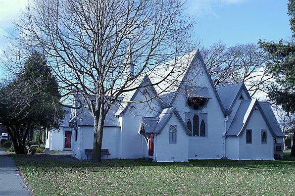
Located in the Christchurch suburb of Addington, the Church of St Mary the Virgin Historic Area contains an English style church and yard that reflects the efforts of the early Canterbury settlers to recreate the familiar village landscapes they left behind. The origins of the church date from 1863, when notable Canterbury settler, and later premier, Henry Sewell (1807-1879) subdivided his land to create the suburb of Addington, and set aside an acre of land for an Anglican church. The church was built in 1866-1867 and extended by the noted Gothic Revival architect Benjamin Mountfort in 1880-1881, to accommodate the growing parish. By the 1890s the parish was seen as financially secure and was consecrated in October 1892. Further extensions occurred to the church in 1900. Over time associated structures were built around the church. In 1877 local architect J.C. Maddison built a vicarage, which stills stands across the road from the church today. A belfry was erected in 1907 to commemorate Premier Richard Seddon (1845-1906), who had been closely associated with the church since his daughter had married one of the vicars. The lych-gate, which provides the main entrance into the church grounds, was erected in 1921 as a memorial to those parishioners who had died during World War One. Other smaller gates were erected to commemorate specific parishioners on the east and west sides of the square. Today the Church of St Mary the Virgin is one of the earliest timber churches still standing in Christchurch and, along with its lych-gate, bell tower and setting, is recognised for its heritage values through its listing in the Christchurch City District Plan.
Location
List Entry Information
Overview
Detailed List Entry
Status
Listed
List Entry Status
Historic Area
Access
Private/No Public Access
List Number
7516
Date Entered
6th June 2003
Date of Effect
6th June 2003
City/District Council
Christchurch City
Region
Canterbury Region
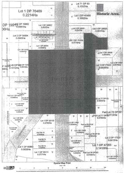
Extent of List Entry
Extent includes the land described as Pt RS 72 (RT CB380/110), Lot 2 DP 70154 (RT CB40D/375), Sec 1 SO 17996 (RT CB33K/124), Canterbury Land District and part of the land described as Legal Road, Canterbury Land District, and the following structures thereon: Church of St Mary the Virgin, associated belfry and lych gate, former vicarage, and memorial gates on the east and west sides of the church’s land parcel. Church Square itself is included as part of the extent. Refer to the extent map tabled at the Heritage List/ Rārangi Kōrero Committee meeting on 26 March 2020.
Legal description
Pt RS 72 (RT CB380/110), Legal Road, Lot 2 DP 70154 (RT CB40D/375), Sec 1 SO 17996 (RT CB33K/124), Canterbury Land District
Status
Listed
List Entry Status
Historic Area
Access
Private/No Public Access
List Number
7516
Date Entered
6th June 2003
Date of Effect
6th June 2003
City/District Council
Christchurch City
Region
Canterbury Region
Extent of List Entry
Extent includes the land described as Pt RS 72 (RT CB380/110), Lot 2 DP 70154 (RT CB40D/375), Sec 1 SO 17996 (RT CB33K/124), Canterbury Land District and part of the land described as Legal Road, Canterbury Land District, and the following structures thereon: Church of St Mary the Virgin, associated belfry and lych gate, former vicarage, and memorial gates on the east and west sides of the church’s land parcel. Church Square itself is included as part of the extent. Refer to the extent map tabled at the Heritage List/ Rārangi Kōrero Committee meeting on 26 March 2020.
Legal description
Pt RS 72 (RT CB380/110), Legal Road, Lot 2 DP 70154 (RT CB40D/375), Sec 1 SO 17996 (RT CB33K/124), Canterbury Land District
Cultural Significance
St Mary's has been the centre of the Addington suburb since Henry Sewell had the subdivision drawn. The new suburb was originally settled by people of relatively low income, workers in the developing railway, the nearby gaol or army base. The church's evolution reflects the financial circumstances of parish members. As the centre for Anglican worship in Addington the church has spiritual significance for its congregation. To the wider community it has cultural value as a special feature of Christchurch's colonial beginnings. There is widespread public esteem for the church and its environs. Local residents of Addington as well as specific parish members appreciate its history and aesthetic qualities. Wider recognition of its special values is evidenced by the "Friends of St Mary's Church", a support group formed in 1983, with members from the whole city and beyond. Spiritual values link with the belfry as a memorial to Seddon, the lych gate as a war memorial and the two side gates constructed as memorials to parishioners. In the church itself there are further memorials to past parishioners.
Historic Significance
Historical Significance or Value The Church of St Mary the Virgin, 1866/7, is a rare example of the first phase of timber Anglican churches built in the immediate environs of Christchurch. Intended as a temporary structure, it has been extended and altered over the years to meet contemporary needs. It demonstrates the principles of church design espoused by the Ecclesiologist movement as well as the desire of the founding fathers of Canterbury to establish churches to serve each residential area of the developing province. Henry Sewell, a notable member of the Canterbury Association and a prominent political figure, planned the church square, gifted the land and funds for the church. Richard Seddon was another eminent politician associated with the church, the belfry being erected by the community in his memory.
Physical Significance
Ecclesiologically "correct" in its original form and plan, St Mary's church is in the approved Gothic revival style. The integrity of the very simple original building was maintained as later additions were made. Four notable 19th century architects were responsible for the church's form and character, while recent adaptions to meet changing liturgical requirements have been made by Don Donnithorne, esteemed for his church designs. The former vicarage was designed by another prominent 19th and early 20th century architect, J.C. Maddison. Examples of Speechly and Crisp's work are relatively rare as their time in Canterbury was brief. St Saviour's Church at Templeton, 1868-74, which they designed is registered Category II. Although a number of Benjamin Mountfort's early timber churches are still in use in Canterbury, all of his buildings are considered significant today as demonstration of his creative abilities and his evolving approach to style. Frederick Strout's aisle addition, though capably and sympathetically designed, owes much to Mountfort's planning. It was perhaps because St Mary's was originally clad in timber and then stuccoed in 1960 that it was not considered for registration in the past. Within the Christchurch area the only timber Anglican church older than St Mary the Virgin at Addington is the church of St Mary at Heathcote (unregistered) built in 1860. The Addington St Mary's is notable as the work of Speechly and Crisp and Mountfort, as a representation of the Ecclesiologists' design principles rendered in timber in the simplest form to provide the most basic facility, and as a church planned to provide temporary accommodation but which has been in use for 135 years. Apart from the Anglican Cathedral, Christ Church (Cat.I), St Mary's is the only church in Christchurch set in its own square. However, the environs are quite different, the cathedral being centred in the heart of the business district while St Mary's church has an almost rural or village setting. In 1907, the Church Property Trustees described it as the "prettiest church ground in the diocese". It remains unique within the attractive surroundings featuring historic trees, the Gothic belfry and Arts and Crafts styled lychgate, all of which provide reference to English country churches and their settings.
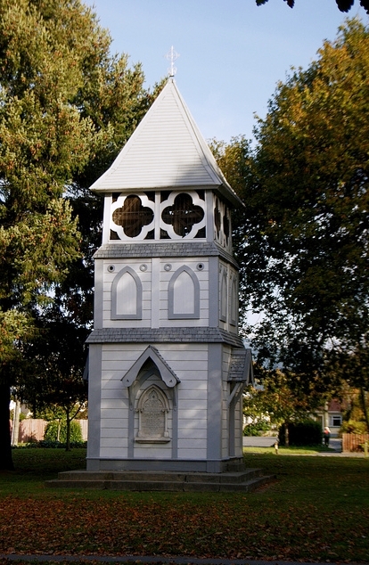
In 1856 Rural Section 72, an area of 50 acres bounded by what are today Moorhouse Avenue, Selwyn Street, Jerrold Street and Lincoln Road, was purchased from the Canterbury Association by Reverend George Robert Poulson who was from Addington, near London. In 1860 he sold the land to Henry Sewell (1807 - 1879), a leading figure in the early administration of the Canterbury Association, the first elected member of Parliament for Christchurch and for a short period, the first Premier of New Zealand. In 1863 Sewell subdivided R.S. 72 for residential purposes, advertising the quarter acre sections for sale in "the new suburb of Addington". At the same time he set aside a square acre of land for a church in the centre of this subdivision with a further 4 acres to the north east for a vicarage and glebe, or for "charitable and educational purposes". This land was gifted to the Anglican Diocese along with a hundred pounds towards the building of a church. . The diocesan authorities first built an orphanage on the corner of the large glebe section in 1864. This orphanage closed in 1870 when larger numbers of children were in need of care and the building was inadequate. Rather than adding to the existing building the Provincial Government had the children transferred to a disused hospital in Lyttelton. As soon as the orphanage was built however, it was used for church services. At this time Addington was part of the parish of St Michael and All Angels. At the end of 1864 an assistant curate was appointed for Addington and by 1866 the vicar of St Michael's decided it was time to erect a separate church building. A committee was formed and the neighbourhood was canvassed for subscriptions to be added to Sewell's original 100 pounds. When 264 pounds was accumulated it was decided to build a church room which could be used as a Sunday School as soon as a more substantial church was built. In June 1866 Speechly and Crisp, architects for Christ Church Cathedral, prepared plans for a church room to seat 88 people. Costs proved higher than anticipated and the tender of Mr Stewart for 279 pounds was accepted for the building to be completed without linings or seating. The position for this building was fixed by the committee in the south-east corner of the pegged out square, leaving the central position available for a new permanent church. No formal foundation laying ceremony occurred, nor was there any formal dedication or opening for what was seen as a temporary building, though the name St Mary the Virgin had been bestowed. A tea meeting on 19th February 1867 celebrated the small basic building's completion, but by November 1868 a lack of support led to the church's closure for the next two years. From 1870, despite financial constraints, considerable progress was made under the leadership of Reverend Frederick Brittan (1848-1945), assistant curate at St Michael's. Congregation numbers increased, a lectern and prayer desk were donated, a harmonium was purchased, altar rails erected and sisal matting was laid in the chancel. The plain doorway for entrance to the church on the north side of the nave was replaced by a window when a porch and doorway were added to the west end. Linings were now added to the interior and at the end of 1871, 12 pews, still in use today, were purchased by the vestry. Thus, the very sparsely finished building of 1867 had acquired the more typical appearance of a colonial church. In 1873, after Rev Brittan's resignation, services were conducted by Rev. John Raven (1821-1886) who took no salary as he was aware of the church's poor financial position. Addington was not a wealthy suburb, accommodating many of the workers employed in the establishment and maintenance of the railway which was based in this area. Raven offered the 20 pounds available for his salary for the purchase of stained glass windows for the sanctuary, suggested the subjects - the Virgin and Child, St Joseph and St John the Divine - and these were ordered from Lavers and Baraud of London. They were installed mid-1875 replacing the original quatrefoils. One of these quatrefoil windows was later used in the present vestry. By 1875 the Addington parochial district had developed to the point where a separate parish was established, the first vicar being Reverend Herbert East(?-1919). Since the closure of the orphanage on the glebe that building had been used as a day school and then as accommodation for members of the clergy. In 1877 it was leased as a residence to a church warden of St Mary's and the diocese agreed to the building of a vicarage. J.C.Maddison (architect of Christchurch's Government Buildings, Cat. I) designed the two storeyed timber residence which was completed in February 1878. With its own grouping of mature trees the house is sited to the north-east of the square, directly opposite the church. When the boundaries of the parish were enlarged in 1880 and the increased numbers put pressure on the existing building, the question of the long planned "permanent" church arose. The financial security for the parish was not considered adequate and the vestry decided that the existing building should be the nucleus for an enlarged church. Benjamin Woolfield Mountfort drew plans for the lengthening of the nave and also proposed how side aisles might expand the width. For a cost of 241 pounds the nave was extended to the west, the porch was moved from the west end to the north side of the nave, a stringcourse beading was added to the internal lining to form a dado, a new vestry was added to the north and the existing vestry was converted to an organ chamber. A bell cote was added over the western gable and buttresses were positioned to support the lengthened nave. When work was completed in 1881 the church had doubled in size. This addition confirmed the continuing use of the building, rather than its originally planned replacement. In June 1892 Rev. East was replaced by Rev. Walter Bean (1857-1949) who came from Kumara where he had married the eldest daughter of Westland's Member of Parliament, Richard John Seddon (1845-1906). This began an important association for the church with the prominent politician who shortly led the country as Premier. From 1892, whenever Seddon was in Christchurch he stayed at the vicarage with his daughter and worshipped at St Mary's. By this date a greater sense of financial security was seen for the parish and in October 1892 the church was consecrated. Architect Frederick Strouts supervised the construction of the south aisle addition in this year, enabling the building to seat 300. In 1900 when the northern aisle was added, church warden Augustus Schwartz supervised the work. Rev Bean had expressed to the vestry his concerns about the inadequacy of the church bell in the small bellcote at the church's west end. Not long before his death on June 10 1906 Seddon had left some money for "some bells worth ringing" for the church. This became the nucleus of a fund to erect a belfry with a set of bells as a memorial to him. Mr Schwartz drew up a plan for the structure but it was not approved by the Church Property Trustees as they considered it too plain and simple for "the prettiest church ground in the diocese". The architect J.C. Maddison made suggestions for its modification and on 22 December 1907 the belfry with its peal of eight bells was formally dedicated by Bishop Julius and opened by the new Premier, Sir Joseph Ward. The lych gate was constructed in 1921 as a memorial to parishioners who had died in the 1914-18 World War. It is set in the centre of the north side of the square and was constructed by J & W. Jamieson & Co. Parish records do not tell us who designed the Arts and Crafts styled gate which may have been from a contemporary pattern book. Rev. Bean and his wife jointly served the parish until the vicar's retirement in 1933 when the major contribution they had made to the church community and the suburb as a whole was widely acknowledged. The parish had struggled to survive in the depression years and in 1935 a loan was obtained to deal with the problems of overdue maintenance to church and vicarage. The church's shingle roof was replaced with corrugated iron, the fleche was removed, and elements of the interior were lined with fibrous plaster. In the following decades under a succession of capable and dedicated vicars the parish underwent ups and downs as the character of the area gradually became more industrialised. Financial constraints prevented the undertaking of regular maintenance and it was seen as a great improvement to stucco plaster the exterior of the church in 1960 and the vicarage in 1962. A donation in 1960 enabled the fleche, removed in 1935, to be reconstructed at the east end. In the early 1980s a proposal by the City Council to change the zoning of areas of Addington from residential to commercial was successfully opposed by the residents. However, the congregation of St Mary's has become insufficient to maintain a permanent vicar. Over the years areas of the glebe land was sold, the parish hall built in the 1950s was also sold and the vicarage was leased. After Rev Hugh Bowron's departure in 1995 a Priest in Charge was appointed and in 2001 St Mary's was licensed for Total Ministry with people licensed by the Bishop to undertake specific church duties.
Speechly and Crisp's design for the original school-room/church demonstrated the principles of the Ecclesiologists as adopted by Bishop Selwyn and the Canterbury Association. Features of the Gothic Revival Style in colonial Anglican churches evident at St Mary's are: -Differentiation of chancel and nave apparent both internally and externally -Timber frame with weather board cladding -Steeply pitched roof with bell cast eaves -Pointed arch motif in windows and Gothic quatrefoil and trefoil motifs -Exposed trussed ceiling - roof construction expressed internally Despite the fact that the original building was intended to be only temporarily used for church purposes Speechly and Crisp clearly were mindful that its appearance should be appropriate for that function. The apsidal eastern end which defined the chancel was lit by quatrefoil windows and a fleche surmounted the roof ridge at the sanctuary's junction with the nave. The simple external cladding of horizontal weather boarding was enlivened along the nave by vertical and horizontal facings, while the sanctuary was emphasised by vertical boarding of the lower wall sections. A rose window was the main feature of the western gabled end and groups of three lancet windows lit the nave. The simple, deeply hooded entry porch planned for the south western end of the nave was not built. (A door on the north side of the nave provided direct entry. It was replaced in 1871 by a more spacious gabled porch at the western end.) Internally, the trussed roof structure features high collar ties, king post and arched brackets. Benjamin Mountfort brought his expertise in Gothic revival church design to the additions he planned in 1880 to enlarge the capacity of the church. He retained the simplicity and overall character of the existing building as he doubled its size. The length of the nave was extended from 26 (7.92 metres) to 56 feet (17.07 metres) with the western end re-used and the roof structure repeated. The entry porch was relocated to the north side of the nave's western end and timber buttresses were added to brace these greatly lengthened nave walls. Gabled vestries were added to each side of the chancel and a small bell-cote topped the western end gable. Whereas the earlier sarking of the roof structure was plain, Mountfort used diagonal sarking and thus the demarcation of the 1880 extension is apparent today. Frederick Strouts followed the dotted line which Mountfort had indicated on his 1880 plan to enlarge the nave by the addition of a gabled south aisle in 1893. Although it is more usual for Gothic Revival churches to feature aisles with lean-to roofing, there were medieval precedents as well as examples in Christchurch. It was a practice used for extensions to colonial cottages and also in some churches, for instance the first St Mary's Church at Merivale and St Luke's Church in Kilmore Street, (both built in 1865 and since replaced). Provision of lean to roofing would have been complicated at Addington because of the low height of the nave eaves. Strouts designed a roof structure which complemented that of the nave. Here horizontal sarking is laid on rafters braced between collar ties and support posts. The arcade of support posts between nave and aisle provides a light demarcation which does not impede the openness of the internal space. In 1900 Augustus Schwartz also followed Mountfort's proposal for the north aisle addition when he drew up the plans and specifications. The overall form of the church with its picturesque roof line and lively massing of elements has not changed since 1900. However, the articulation of the external timber cladding was lost when it was decided in 1960 to plaster the church with a stucco finish, a popular solution at this date to overcome general maintenance costs. Don Donnithorne has modified the internal arrangement of the sanctuary in line with changing liturgical requirements. The minor additions to the porch and to provide service rooms at the west end have enhanced the practical usage of the church without affecting its original colonial Gothic Revival character. The Square: The original acre of land gifted for the church was set within the four enclosing streets of the square. In 1870 the surrounding area was still unformed and the church's environs not yet developed. During the next three years lawns were sown and holly trees planted around the church yard's perimeter. The Domain Board donated trees, beginning the establishment of the fine collection which remains today. Paths provide walkways through the grounds. The church is located at the eastern side of the square rather than in the central position but it has been balanced by the positioning of the belfry to the west. Today, the buildings are partially screened from view by the large mature trees which provide a major focus from the streets which terminate at Church Square. On the north side the lych gate provides a strong accent, while to the east and west there are small memorial gates, erected to commemorate former parishioners. In the 1980s a sculpture by Lou Summer was set in the square near the lych gate, its modern forms causing some controversy. It was a model he had prepared for the larger work commissioned to grace the entrance to the Timaru Public Library. The holly hedge had become difficult to maintain in recent years despite assistance with its trimming by nearby army and prison workers. It also tended to enclose the church grounds, deterring entrance by the wider community while screening the activities of vandals. In 1992 the parish and the City Council worked together over an upgrade for the square. The old hedge, in which holly was now intermingled with hawthorne, was removed and replaced by a post and chain fence. The road around the southern half of the square was narrowed and closed to through traffic. It has been landscaped as part of the old reserve. The Vicarage: Over the years the area of glebe land has been progressively reduced from the original 4 acres (16,200 square metres), so that the vicarage is set within 1002 square metres today. The large 6 bedroomed house was sited conveniently close to the northern boundary of Church Square and now the northern and western boundaries are much reduced. The major expanse of surrounding land is to the east providing a sheltered, secluded haven for the residents. The two storeyed residence's external form remains much as it did when first completed, only the hoods over the smaller sets of casement windows having been removed. Strong protruding gables enliven each façade and two grand chimneys cap the roofline. The Gothic styled front entrance porch sheltering a pointed arched door provides a major decorative element on the western side. There have been many internal changes and updates since Rev Bean's occupancy when Richard Seddon made small improvements to make his daughter's life more comfortable. In 1962 the exterior was stucco plastered and considerable modernisation was done when Rev. Williams moved in with his family 1981. In recent years a separate room was built adjoining the north west corner of the vicarage. This is used as the parish office, while the house itself is leased as a residence. The Belfry: The Gothic styled timber belfry is sited to the west of the church. It is square in plan, tapering slightly as it rises to the 45 feet high apex of the roof. The base section is strongly articulated, with the marble Seddon Memorial plaque on the north face and entrances to the bell chamber on the east and west sides. These elements are each sheltered by a decorative, pointed arched hood. On the southern side there is a pointed arch panel as a minor motif. A simple blind arcade of lancets decorates the central section while open quatrefoils screened by wire mesh form the upper level where the bells hang. Each level of the belfry is separated by sections of shingled roofing, providing a strong delineation. The roof was originally clad with shingles with a small gablet on each face. These were removed when the roofing was replaced with the current steel material. The 8 bells purchased from James Barwell of Birmingham in 1907 remain in place. The Lych Gate: There is no record of the designer of the lych gate constructed as a memorial to 'the boys of Addington who fought in the Great War 1914-18'. Similarly styled lych gates were constructed at this time when the Arts and Crafts movement continued its influence. Pattern books featuring examples of this type of structure were available. The lych gate's plan and character harmonized well with the square's existing features. Constructed of timber on a stone base it has Gothic forms which reflect elements of the church and belfry. Overlying the strongly Gothic shapes are the details of timber work illustrating the Arts and Crafts' influence. These can be seen in the flattening of the main arch and the emphasis on craftsmanship in, for instance, the stop champfering and dentilation. The lych gate is centrally located along the north boundary of the square, providing a strongly accented entrance to the church grounds. It is aligned with Grove Road, drawing the eye as one approaches the square from the central city.
Completion Date
6th June 2003
Report Written By
Pam Wilson
Information Sources
Personal Communication
Personal Communication
Scotter, 1967
W.H Scotter, The Church of St Mary the Virgin, Addington, 1867-1967, Christchurch, New Zealand
Conservation Plan
Conservation Plan
Report Written By
A fully referenced version of this report is available from the NZHPT Southern Region Office. Please note that entry on the New Zealand Heritage List/Rarangi Korero identifies only the heritage values of the property concerned, and should not be construed as advice on the state of the property, or as a comment of its soundness or safety, including in regard to earthquake risk, safety in the event of fire, or insanitary conditions.
Current Usages
Uses: Civic Facilities
Specific Usage: Square - public
Uses: Commemoration
Specific Usage: Memorial gate/fence/wall/arch
Uses: Religion
Specific Usage: Belfry/Bell tower
Uses: Religion
Specific Usage: Church
Uses: Religion
Specific Usage: Lych Gate
Former Usages
General Usage:: Religion
Specific Usage: Vicarage/Manse/Presbytery/Rectory
Stay up to date with Heritage this month
