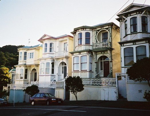
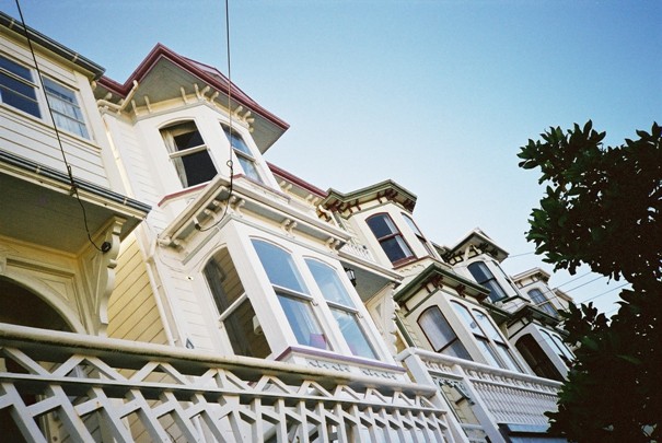
The five houses numbering 56-64 Wright Street, on the border of Newtown and Mount Cook in Wellington, are close siblings. Speculative builder Harry Crump built them as a singular project in 1905. Though very similar in appearance, and a visually striking group as a result, each possess certain features that are their own alone, representing the tastes and choices of their various owners over time. The surviving evidence suggests that none of the houses or their occupants have a notable or unusual history. The lives of 'ordinary people' are not necessarily recorded for historians to fossick around in at a later date. Ideas and propositions about their past must be constructed from the remnants of information that remain. In this way, the houses on Wright Street can be seen, in a general fashion, to 'speak for' the other similar domestic structures in the Newtown / Mount Cook area. Their construction reveals, in microcosmic form, ideas about the historic development of this area. Their representative or typical nature in terms of their origins and history are arguably of more general utility in this way than something less common.
The Development of Newtown and Mount Cook
The New Zealand Company laid much of the land comprising the modern suburbs of Newtown and Mount Cook out into Town Acre sections in 1840. Both were on the borders of the grid plan and backed onto the land designated for the town belt, which was 'reserved for the enjoyment of the Public and not to be built upon'. Of the two, Newtown has expanded the most beyond these original borders, forming as it does the southern most section of the plan. Wright Street, named after early landowner John Fortescue Evelyn Wright, is formed on this plan and includes Town Acre 703 that was to be built upon in 1905 by Harry Crump.
Mount Cook was closely associated with military activities and had housed various related activities, such as the Mount Cook barracks, an immigration depot and a jail for Maori prisoners from the early period of Wellington's development. A prison was constructed on the top of Mount Cook overlooking the Te Aro flat in 1879 and was a prominent landmark for some time until it was replaced by the Dominion Museum in 1934.
Unlike Mount Cook, Newtown was more physically removed from the city centre, and for some decades remained relatively undeveloped. A stream that flowed from Newtown Park at the south end of Newtown to Clyde Quay in the city intersected the land, and 'a morass of flax, raupo and tussock grass' surrounded this stream. For much of the nineteenth century the land was farmed and market gardens sprung up around the area. Though it was divided into Town Acres, it was more countryside than town.
The development pressures experienced in Te Aro during the late nineteenth century initially drove the evolution from farmland to suburb. Flat space had been at a premium in Wellington from its beginning. Though the Te Aro flat offered an extensive area for development, the hills hemming in Te Aro did place some pressure on the flat because they were less desirable areas for development, and because much of this land was reserved as town belt. At this time people commonly lived close to their place of work, which is also a relevant factor to consider.
A fairly low rate of population increase in Wellington harnessed this development pressure during the early period. However, Wellington experienced a rapid period of growth in the 1870s. The population then doubled between 1880 and 1900, and this lead to a building boom in the city. The Town Acre dimensions were readily subdivided and haphazard and often miniscule subdivision ensued. The pressure had to give, and the southern suburbs provided one important outlet. After 1870 over 70 percent of the Wellington district's population growth was encompassed within the city, as laid out 40 years previously. Unlike the other major cities of Auckland, Christchurch and Dunedin, which had scattered populations, the majority of the population increase from this period was found in Mount Cook, Mount Victoria and Newtown. These areas, as well as parts of Aro Valley still contained open spaces that could be developed for housing, unlike the Lambton and Thorndon areas, which were well built up by this time and evolving into commercial usage. First though, migrants from the central city and beyond would need a convenient way to access these southern reaches.
Urban Transport in Wellington
The role of public transport, and in particular the trams, is well acknowledged as a significant factor that enabled the expansion of Wellington beyond the city centre. Prior to 1878, when trams made their first appearance, horse-drawn omnibuses did provide services to outlying areas such as Newtown, Island Bay, and Kilbirnie. However, these were expensive and in consequence not a realistic form of transport for the working man and woman. Trams were very cheap in contrast, and the omnibus companies also dropped their prices in response to the threat posed by trams.
The line was originally confined to the city, but was extended to Newtown through Riddiford Street down to the intersection with Constable Street within a year of opening. This had a marked impact upon the attraction of land for dwelling purposes beyond the city centre. The line ran through the middle of Mount Cook south to Newtown, and though it did not turn up to places such as Wright Street, these outer streets were not too far away on foot. As an early real estate poster for a large subdivision in Newtown remarked: it is curious to see how what seemed long distances have dwindled, and how open spaces of a few years ago have been enclosed in the inexorable grasp of a spreading population. The trams were electrified at the turn of the century, with electric trams running to Newtown from 1904.
The population of Newtown and surrounding areas grew accordingly, particularly from the 1880s. It is significant that the Cook Ward, which comprised part of Mount Cook, Mount Victoria and Newtown, accounted for over half of Wellington's population growth between 1878 and 1901.
Other Development Factors
Other relevant factors contributing to this development pattern included the appearance of secondary industries in this area, such as soap factories and leather manufactories, which provided sources of employment. A major industry that had a significant impact upon the landscape of the area was brick making. Newtown and Mount Cook were an important source of clay suitable for brick making. By the 1880s Newtown housed around six brickworks, with many more springing up into and during the twentieth century. Mount Cook also housed a number of brickworks, including the Hill brothers around Rolleston Street from the early 1870s and P. Hutson and Company in Wallace Street from the turn of the twentieth century. The Mount Cook jail also had brickworks, and prisoners comprised the labour force. The Wellington Public Hospital on Adelaide Road was built with prison bricks, and would also have been a source of employment.
By 1905, when Crump built the five houses on Wright Street, southern Wellington had already experienced a notable period of urban growth. Wright Street and the surrounding area had become well built-up. While it has not been possible to directly link the construction of these houses to the factors outlined above because, for example, Harry Crump has not left any surviving correspondence, their construction fits into this wider and general context. Crump was a successful speculator, and thus would have had his eye on desirable sites for construction. Wright Street was close to the tramline, to both the industries of the south and city fringe, and the mercantile and government centers in the city. Before looking at the houses and the inhabitants, it is necessary to look at Harry Crump.
Harry Crump, Speculator
According to Irvine-Smith, Harry Crump was a prominent builder, who left his imprint on city streets. This is a fair characterization and his construction of the Wright Street houses in 1905 can be seen as a microcosmic form of his wider building practices. He was born in Yorkshire in England, and after spending some time in America and serving an apprenticeship back in Yorkshire, he immigrated to New Zealand in 1880. Surviving building permit records held by the Wellington City Council archives give a good indication of his significant construction output. A total of 156 building permits are associated with Crump in various ways. In many cases he applied for a permit as builder and on behalf of the owner. He also made 31 applications for himself as building and owner. He appears to have entered into partnership with a J.T Hawthorn and made 69 applications under 'Hawthorn and Crump'. This partnership also constructed and designed buildings, which it may have later on-sold.
Crump first appears in the records on an application to construct two dwellings in Tasman Street in Mount Cook in 1892. From this year up until 1908 he was consistently making applications for building permits, principally to erect new structures. His imprint ranged across the city and surrounding suburbs, and particularly concentrated on Kelburn, Thorndon, Te Aro, Mount Victoria, Mount Cook and Newtown. It appears likely that he was a builder-architect, as most of the applications do not list separate architects.
As well as building numerous structures, he also owned a great deal of land over time and named streets. He acquired the Wallace Estate in Newtown in 1898, which was located around Adelaide Road, and owned a considerable amount of land around the Government House in Thorndon, which he called 'Clermont', which was also the name of a street in this area in Kelburn towards The Terrace. He named Myrtle Crescent in Mount Cook, Lauriston Street in Mount Victoria (now Patterson Street) and constructed Kensington Street in Te Aro in 1903.
It is unclear when Crump ceased his construction activities. Irvine-Smith notes that he retired to Dunedin, and he was still alive at age 92 when she published her book in 1948.
The Wright Street Houses
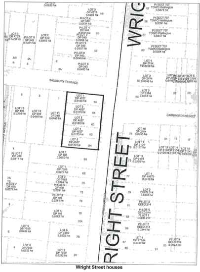
Harry Crump acquired the land in Wright Street on which he constructed the five houses in 1903. At this point the land was comprised of Lots 9 and 10, DP 340. Prior to Crump's acquisition, the land had a number of owners. As noted above, the houses were constructed on part of the original Town Acre 703. The first certificate of title for this, and Town Acres 701 and 702, was issued to Morgan Stanislaus Grace, a surgeon, and Edward Stafford, a solicitor, in 1886. Five days later the land was transferred to Frederick de Jersey Clere, Alexander McTavish, Charles Tatum and Christopher Richmond. It was soon after subdivided, creating 15 lots of various sizes. These lots were progressively and rapidly sold off. One of the partners, Charles Tatum, purchased lots 9 and 10 in 1887. Five months later he sold the two lots to Frederick Wilson, a solicitor of Wellington. Wilson may have built a house on the site at some stage, as Thomas Ward's 1891 survey map of Te Aro depicts a two-storied structure with eight rooms and a verandah in the middle of lots 9 and 10.
Crump acquired lots 9 and 10 from Wilson in two parts in 1903. The northern section, which is currently numbers 58-60, was transferred in September, while the southern section (numbers 62 and 64) was transferred one month later. Two separate titles were then issued for the northern and southern sections.
Crump lodged a building application with the Wellington City Council to construct five two-storied houses in August 1905, and estimated that the construction would cost £3000. The building plan indicates that the interior of the five houses was the same, with an entrance hallway on the right-hand side, a living room at the front, bedrooms on both floors and washing and kitchen areas at the back of the house. Crump appears to have designed the buildings himself.
Crump owned all 5 houses and rented them out until they were sold as two lots to Margaret Price, wife of Charles Price, a builder of Wellington, in 1913. In 1920 Lots 9 and 10, which comprised the land on which the houses stood, was resurveyed. The land then became Lots 1-5 DP 4627 Part Section 703, Town of Wellington. With the exception of Lot 3, these sections were purchased in 1920 by the Government, as part of a drive to combat urban slums and housing shortages. Lot 3 was transferred to Mary Davis in March 1921.
Like Harry Crump, Margaret Price did not live in any of the houses during her period of ownership, and they were instead rented. For most of their history, the tenants of the houses may be loosely described as lower middle-class, with occupations such as clerking, sales and manufacturing. The combination of owner-occupation and tenant-occupation varied over time, and some of the houses are still operated as rental properties.