TRADITIONAL CONTEXT:
The Takiroa Historic Area is a significant landmark in the traditions of the Ngai Tahu Whanui. The dominant feature of this historic Area is a rock shelter that lies on an ancient pathway following the Waitaki River between the mountains and the sea. The headwaters of the Waitaki River are fed by ka roimata o Aoraki - the tears of Aoraki - the ancestral mountain of Ngai Tahu. The people of Ngai Tahu are descended from Aoraki - the most sacred of their ancestors - who was the first child of Raki (the Heavens) and Poharua Te Po (the breath of life found in the womb of darkness).
Some of the earliest traditional accounts associated with human inhabitation of the lower South Island are connected to the voyaging waka named Arai-Te-Uru. Rongo-i-tua was a voyager from Hawaiki who introduced kumara to the Kahui-tipua people of the South Island. The Kahui-tipua people assisted Rongo-i-tua in the construction of a canoe in order for him to return to Hawaiki and secure additional Kumara for cultivation in the south (Stack 1879:159). On its return to the South Island, the Arai-Te-Uru encountered a fierce storm, and according to J. Herries Beattie's retelling of collected accounts, the crew member named Moko-tere-a-tarehu was lost overboard at the mouth of the Waitaki River (Beattie 2001:26). The canoe was blown further down the east coast of the South Island, and after losing much of its cargo of kumara at the beach known as Kai-hinaki (near Moeraki), the waka was wrecked at Matakaea (Shag Point) where it lies petrified in the landscape (Evans 1997:25).
A. W. Reed's Treasury of Maori Exploration also notes that a waka named Arai-Te-Uru carried a sacred fire from Hawaiki known as Te Ahi-Tapu-a-Uenuku. This fire was buried along the Waikato River (Beattie 1994:435). This sacred fire was dug up by the great Maori explorer Tamatea-Pōkai-Whenua prior to his circumnavigation of Aotearoa New Zealand aboard the waka Takitimu.
This tradition asserts that limestone outcrops such as the one featured within the boundaries of this Historic Area are the legacy of Tamatea-Pōkai-Whenua. During his exploration he traversed the land, using this sacred flame for making fire as he went; as the fires cooled, mounds of pale white ash were left in their place, which became the limestone features that are so prominent in the landscape of this region.
In Johannes Andersen's discussion of the voyage of the Takitimu in his Maori Place Names, Andersen notes that Tamatea-Pōkai-Whenua journeyed along the Waitaki River, and near the river:
'...he cut out a cave for a house, which he ornamented with carvings and paintings. He cut out this cave in order to preserve the tuhutuhi (writing) which was brought from Irihia (beyond Hawaiki) by Uru-whenua and his three brothers.' (Andersen 2000:185)
EARLY HISTORY:
Both iwi history and archaeological evidence show occupation by Maori in the area over an extended period, with the inhabitants utilising a wide variety of natural resources from the diverse environment of the Waitaki River catchment. The date of earliest Polynesian settlement of the Waitaki area remains unknown, but is generally thought to date from at least 1,000 years ago (Symon 2007:8). There was extensive settlement throughout the Waitaki Valley when the moa existed, as shown in the widespread archaeological remains of moa bones in cultural contexts.
GEOGRAPHICAL CONTEXT:
The Takiroa Historic Area contains historic places which can be considered as part of chain of moa-hunter period sites recorded in the Waitaki Valley stretching from Korotuaheka at the river mouth, to the rock art sites at Kokoamo and Maerewhenua, to Otakaroa, to the sites at the junction of the Upper Waitaki with Shepherd's Creek and the Ahuriri River.
EVIDENCE OF OCCUPATION:
While the traditional ways of Maori life had been influenced to some extent by exotic elements by the mid 19th century, many of the old ways still flourished, and valuable insights are available from surveyors and missionaries records made while travelling through the area in the 1840s. On January 9th 1844 Edward Shortland noted 'a ruined hut and a cultivation ground (at) a small glen in the hills, where there was plenty of wood and a stream of water' (Shortland 1852:196) at nearby Papakaio, also on what is now State Highway 83. The following day his group walked to Te Puna a Maru, then the next day established a camp on the banks of the river several miles downstream.
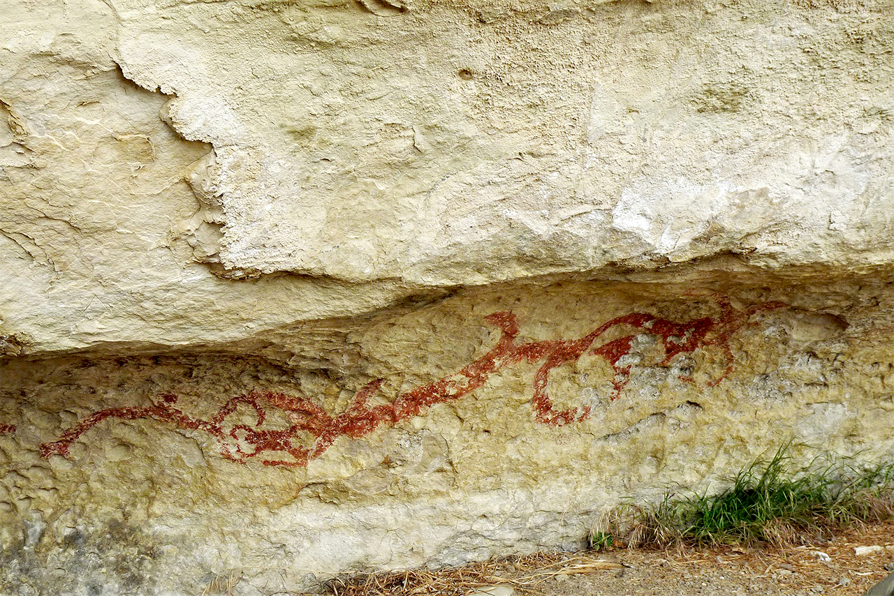
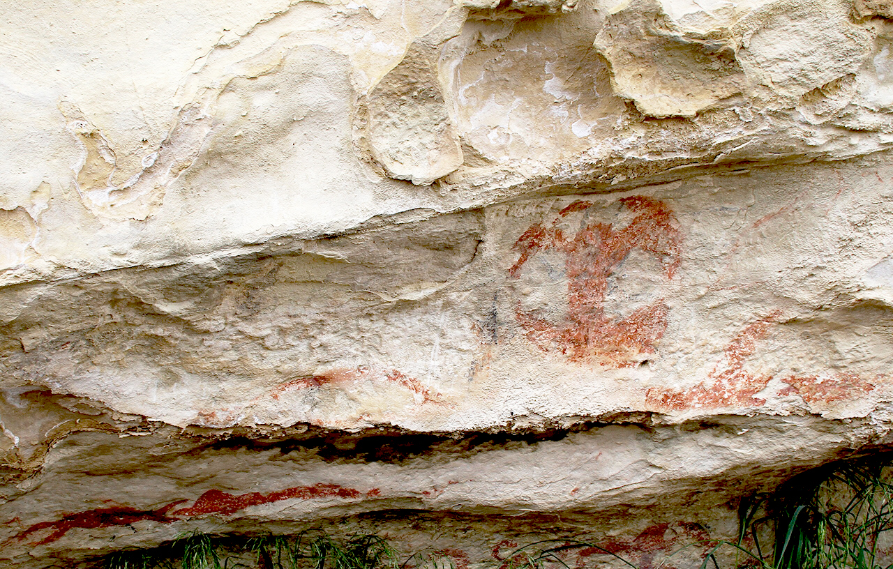
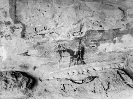
The earliest known European recordings of rock art in New Zealand were taken at Takiroa by Walter Mantell, who sketched a group of drawings of the site in 1852. An account of his findings at Takiroa was made to the Fifth Meeting of the Wellington Philosophical Society on September 19, 1868 in his address on 'The Moa', which was also discussed in the first volume of the Transactions and Proceedings of the Royal Society of New Zealand, along with images of the Takiroa Historic Area and some of the rock art which is still evident today (Mantell 1868:18).
Although the rock art at Takiroa was recorded by Walter Mantell in 1852, the first investigation of the archaeological deposit in the shelter floor occurred more than four decades later when Augustus Hamilton visited the site in 1896. The site was also photographed by Hamilton, who was director of the Otago Museum at the time.
In Hamilton's Notes on Murihiku, Read before the Otago Institute on the 9th of June, 1896, he noted of the rock art at Takiroa:
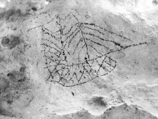
‘On my first visit I carefully examined the walls of the rock-shelter, and found that the figures were easily divided into three classes - First, those painted on the surface of the rock with a thick medium of animal fat or oil in black or red (kokowai), those in black (charcoal?) being apparently the earlier. Secondly, by figures drawn in black without any medium at all, probably with a charred stick or piece of charcoal: these can easily be distinguished from the earlier ones, and careful rubbing will remove them, but has no effect on the others. Thirdly, there are a few initials and marks cut in with knives by the modern vandals or travelling swaggers - to say nothing of one ingenious man who has painted his name in a conspicuous position in orthodox oil-paint.' (Hamilton 1896:170)
Hamilton excavated part of the shelter floor at Takiroa, finding a succession of stratified deposits. This is the only excavation to have taken place at the Rock Shelter (record number 5653), and his description of the deposit is as follows:
‘Beneath the surface-sand which covers the floor was a layer of fine rushes and grass, which had been cut on the neighbouring riverbed for sleeping purposes; tent pegs and fragments of canvas were also found, together with a tin matchbox and some buttons. Below this layer, and nearer to the wall of the shelter, was a thin layer of decayed vegetable matter, with some flax matting of a very coarse character and very much perished. Great numbers of birds' feathers were met with between these two layers of bedding-mainly feathers of weka, quail, a large sea bird (albatross?), paradise duck and shag. A large number of bones of the now extinct New Zealand quail, including twelve sterna, were recovered, and in the deep sand at the Duntroon end I found a very perfect moa-feather, quite black - quite a new colour in moa-feather. In different parts of the Maori level were found the following items: A tooth of a sea-leopard seal (Stenorhynchus); the whole of the natural surface had been polished off, and the fang end rubbed thin to permit of the hole being bored in it: three fragments of bird bone worked down to a sharp point: several cut pieces of Haliotis shell and three valves of Mytilus, the latter probably for preparing flax, the former for carrying paint in for the adornment of carvings or weapons: a few small lumps of red oxide of iron (kokowai): a few small Patellas and some valves of the small Unio from the neighbouring river: several (five) small thin sticks, about 5in. long, with thin strips of flax-leaf tied on to them in a peculiar knot, probably parts of bird-snares: four small chert flakes, with sharp edges. I was not able to examine the talus slope by making a cross-section through it, as I should have liked to have done. From the character of the part of the floor I examined it appears to have been used as a temporary resting place for parties travelling up and down the river.' (Hamilton 1896:172-173)
One of Hamilton's assistants in 1896 was North Otago historian G. B. Stevenson, who reported finding a portion of a rare plaited flax textile in the dry sand of the shelter floor. The textile fragment was later passed on to HD Skinner who examined it, publishing his findings in the Journal of the Polynesian Society in December 1943. Stevenson also described a human skull (presumably Maori) found by a rabbiter around 1890. The skull was hidden in a small cavity at the base of an outlying limestone boulder immediately in front of the rock shelter. It was later removed by police, who carried out a small scale excavation at the time but found no further remains (Stevenson 1947:23).
The South Island Maori Rock Art Project (SIMRAP) was established in the 1990s to undertake an extensive recording and documentation of rock art in the South Island. The project began with a pilot study of sites in the North Otago region, including the Takiroa rock art site. In the 1994 Conservation Plan for the Takiroa site (Harris 1994), Brian Allingham provides a synopsis of his observations of the archaeology in this historic area:
‘The conclusion that the rock art at Takiroa was probably applied over a period spanning several centuries may be supported by the archaeological evidence from the shelter floor. The site was first occupied by people who hunted moa, and this is probably when the first art was applied to the shelter walls. Moa bones, the majority broken limb portions, but including a complete claw (probably Euryapteryx) were recovered by the writer from the surface of an eroding oven deposit exposed on the access track during the course of this project. The same deposit contained numerous bones of extinct New Zealand quail (Coturnix novazelandiae, especially coracoids, humerus, tibia, tarso-metatarsus), and a portion of dog pelvis. Hamilton recorded numerous bones of N.Z. quail in the 1896 excavation, and this combined evidence probably indicates ground-bird hunting was an economic strategy of some of the occupants, possibly on a seasonal basis.
Stone tools picked up during the 1992-93 field work include greywacke discoidal cutters and hammers, and cutters and scrapers of orthoquartzite (‘silcrete') and light brown porcellanite. Two fossil Dentallium shell necklace units were also recovered amongst cultural material on or around the access track. Both of the tubular units are broken, one has the end polished flat, the other has been drilled at the narrow end for vertical suspension. This material, along with the presence of the probable human burial (or re-burial), and artefacts (including a basalt 4A adze - H. Uttley collection) from the river terrace site (I40/57) fronting the outcrop, is reflective of the diversity of cultural activity carried out around the rock art.' (Allingham, in Harris 1994:22)
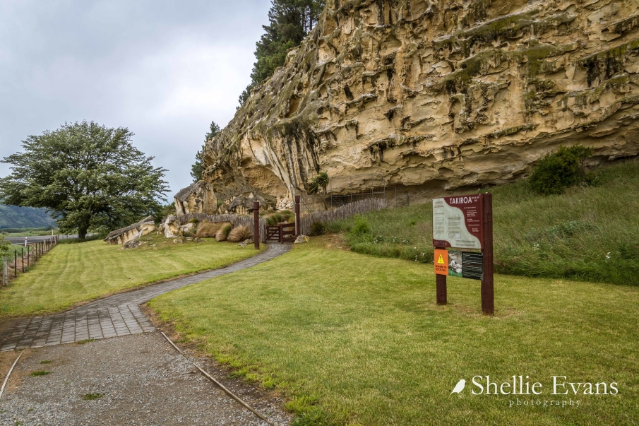
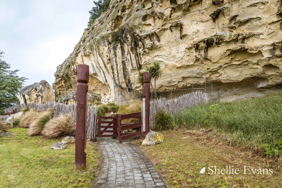
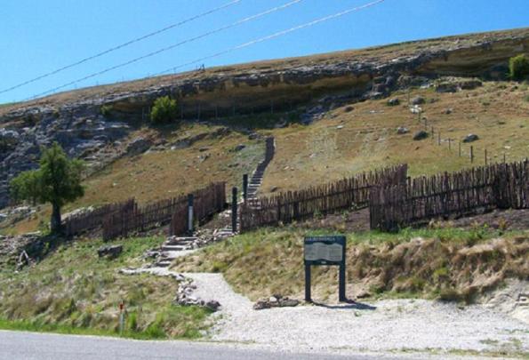
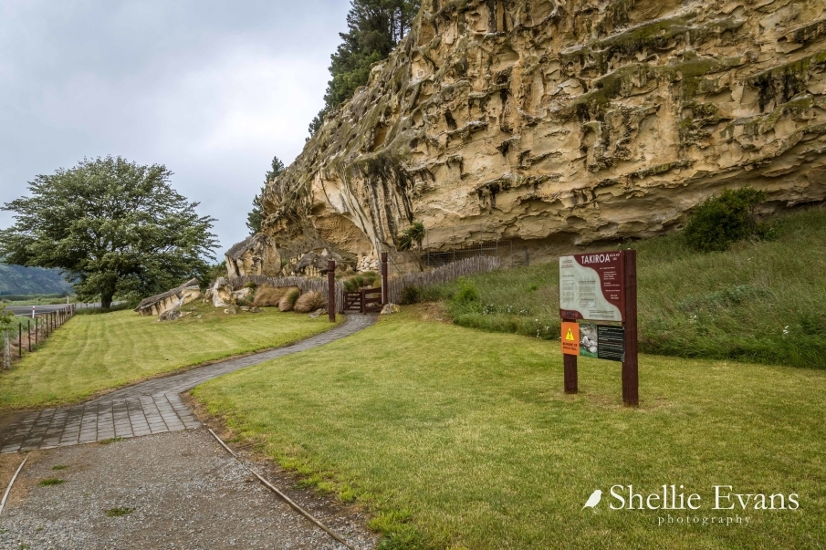
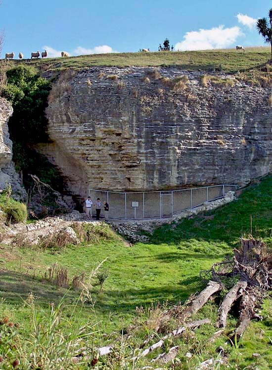
In 1995 a number of improvements were made to the Takiroa site, including the replacement of the protective caging, the creation of a paved walkway, and the installation of interpretive signage. Archaeological monitoring was carried out by Rick McGovern-Wilson as a condition of the Historic Places Trust Authority (1995/4) granted in relation to this work.
During McGovern-Wilson's monitoring, the stratigraphy revealed patches of charcoal and oven stones at the eastern end of the trench. At the western end of the main shelter an area of ash and charcoal containing some hangi stones was also uncovered. Three features described as ‘small scoop hearths' were found in front of the large alcove between the two caged shelters. A few hangi stones and some fragments of shell were identified amongst these (Symon 2007:11).
During monitoring artefacts and faunal material had been collected from this area, including stone flakes, fragments of moa bone, dentallium shells, and the bones of a New Zealand quail. Mc Govern-Wilson concluded that there were ‘extensive archaeological deposits associated with the rockshelter, lying down the slope to the north of the outcrop towards the main highway (McGovern-Wilson 1995:19). These areas were identified on a map produced for the 1994 conservation plan for the site, and has been used to produce the diagram entitled Location of Historic Places within Extent of Registration found in Appendix 1.
The site record forms for the archaeological sites recorded within this historic area yield little information on the archaeological remains, focusing mainly on the rock art. In the file for site I40/9 (relating to Rock Shelter, record number 5653), Michael Trotter is recorded as finding a moa vertebrae on the shelter floor during a site visit in 1966. Site records I40/59 - 61 relate to the shelters adjacent to the main Takiroa cave, and focus on the rock art.
In 2006 Geometria were contracted to carry out a geophysical survey of the area in front of the Takiroa rock art site to shed further light on the location of archaeological features that could be present in the area. The survey revealed two pit-type features within the area investigated. The first of these was located in front of the eastern end of the outcrop, beyond the main caged shelter. Although geophysical survey can identify presence of such features it cannot determine the original function or specific content of these features. Bader concluded that among a number of possibilities, the pit could indicate a crouch burial, and that the size and magnetic resonance of the feature were consistent with such an interpretation. The second pit-type feature was located in front of the cross marking the memorial oak at the edge of the highway. Bader noted that some small objects, including metal, were buried there. This feature was too small to be a burial, and was likely to be associated with the memorial oak and cross (Symon 2007:12).
ROCK ART AND NEW ZEALAND ART:
Maori rock art is also often regarded as the earliest New Zealand artwork, and the rock art sites of South Canterbury and North Otago have been described as ‘New Zealand' oldest art galleries' (Schoon 1947:6). Theo Schoon was employed by the Department of Internal Affairs in 1947 to document rock art, and this experience was formative in the development of his own art (Keith 2007:14). Other New Zealand artists have been influenced by their experience with Maori rock art; Gordon Walters also accompanied Schoon on visits to rock art sites (Thompson 1989: 52), and Tony Fomison was involved in the recording of many sites and sketched the art at various sites extensively. The Ngai Tahu Artist Ross Hemera has often commented on the importance of the rock art in informing his work, stating ‘These drawings, for me, are manifestations of our tipuna. So when I go back to the rock shelters, when I'm visiting, these are the occasions when I feel closest to the spirit of my ancestors.' (Symon 2007).